Copernicus global land cover map
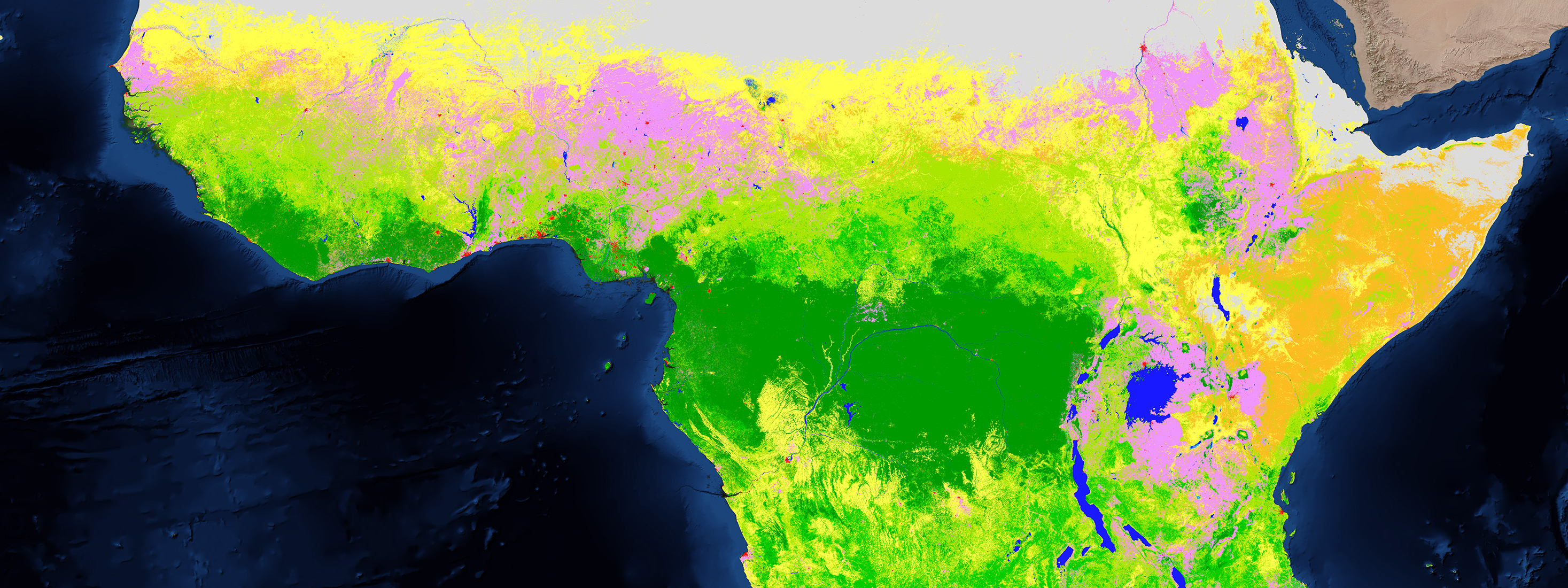
To tackle deforestation or loss of biodiversity for example, organizations first have to know the physical coverage of the Earth’s surface, its use and its dynamics. The Copernicus Global Land Services therefore extend its portfolio and released its first Global Land Cover Map to provide spatial information about land for a diversity of applications ranging from global forest monitoring, global crop monitoring, biodiversity and nature conservation to climate modelling.By merging remote sensing imagery with other ancillary data sources, a highly automated, accurate and cost efficient Land Use and Land Cover (LULC) and Land Use and Cover Change (LUCC) solution generates yearly 100 m land cover maps, following the classification scheme of the FAO Land Cover Classification System (LCCS).
Tune the map to your application
Next to this basic map, a set of continuous cover layers for tree, grass, shrub and bare soil are generated based on a novel approach. Each cover layer provides the fraction of the pixel that belongs to the given class. Through this information users can combine the layers and tune the default land cover classes for their application, and thus support the United Nations’ Sustainable Development Goals (SDGs). Image of Tanzania showing the land cover classification on the left, a google earth image in the middle and the cover fraction compilation on the right.
The data behind the map
The map is generated and validated by IIASA, Wageningen University and VITO Remote Sensing,. It is derived from PROBA-V 100 m and 300 m images and uses training data collected at 10 m resolution and several ancillary data layers.The map and its cover layers were generated on the PROBA-V Mission Exploitation Platform, a scalable Hadoop Spark platform with 1200 executers and 5TB memory. Such platform is able to handle large amount of data and enables us to perform multiple iterations to perform quality checks and improve the products as it takes only a few days to perform all processing steps.
Land cover classification for africa
The first map covers the African continent in 2015. An independent validation shows accuracies up to 10% higher than other global land cover maps. A qualitative comparison shows significant improvements in terms of spatial accuracy compared to other global maps, especially in the Sahel zone, border regions of Sudan, Ethiopia and Kenya as well as eastern Botswana and majority of Madagascar. The map is assessed against both its generic use as well as against its use in different applications. The continuous cover fractions provide information at 100 m resolution with an accuracy of 85-95% (mean absolute error of 5-15%).
What's still to come?
The generation of the land cover maps is part of the Copernicus Service, hence sustained delivery of yearly updates. The next step, planned for mid-2018, is to scale up to the globe, deliver three yearly maps and integrate Sentinel-2 higher spatial details for selected regions.More information can be found on the Copernicus Global Land portal. Users are encouraged to provide feedback through the Geo-WIKI validation tool or through the Copernicus Global Land helpdesk.

An article by
Bruno Smets
Team Leader Natural Capital Accounting
Team Leader Natural Capital Accounting
More info about Bruno Smets


/lewis-latham-0huRqQjz81A-unsplash.jpg)
/Land%20use%20model%20+%20green%20city.png)
