-_-header.png)
FROM MOSSES TO TREES
In 2015, the EU regulation on Invasive Alien Species entered into force, including among others the development of a warning and rapid response systems for biological invasions. Within the DIARS project (Detection of invasive plant species and assessment of their impact on ecosystem properties through remote sensing) we developed guidelines and tools which contribute in the development of such a response system and help to protect biodiversity.
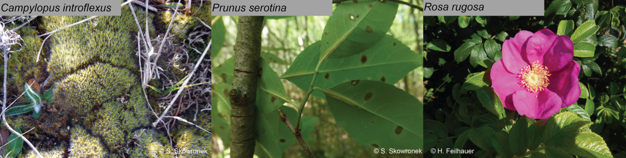
We focused on three different invasive alien plant species: a bryophyte species (Campylopus introflexus); a shrub species (Rosa rugosa) and a tree species (Prunus serotina) and studied these in two different ecosystems: dune habitats in Flanders (Belgium) and on the island of Sylt (Germany) as well as forest stands in the state forest of Compiègne (France).
These species were deliberately chosen as two of these, i.e. C. introflexus (a tiny moss) and P. serotina (an understory species) are challenging to map from a bird’s perspective. R. rugosa served as a benchmark for our methods.
It takes 3 to tango!
Despite the initial challenge, we successfully assessed the distribution and spread of these non-native invasive plants as well as the impact on ecosystem functioning. This success could be largely attributed to the availability of high density LiDAR and airborne hyperspectral APEX imagery for all our study sites. Additionally, these remote sensing data were complemented by a very high quality and indispensable field dataset obtained by very eager PhD candidates and several university students.
By using LiDAR data and APEX data we can retrieve information on the structural characteristics of the vegetation as well as information on the different optical traits (e.g. pigments, leaf area, water content, …). As this is spatially-explicit information, this enables us to move from point observations to continuous maps of the ecosystem functioning and distribution which can be a big step towards a better management of invasive alien species.
 |
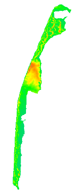 |
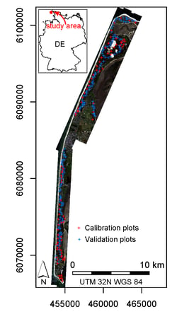
The island of Sylt: Field plots overlaid on a true colour composite derived from hyperspectral APEX imagery (left); Digital Elevation Model derived from LiDAR data (Right); reddish colours denote a higher elevation.
The beauty of remote sensing for biodiversity monitoring
As a researcher I must admit we love to dig into a problem, trying to understand the smallest details. It is of course extremely satisfying if you can translate a problem into insights and solutions and to share these with the community to help in protecting our natural environment.
The DIARS project gave us several key findings , all published as international peer-reviewed publications. Here’s a short overview
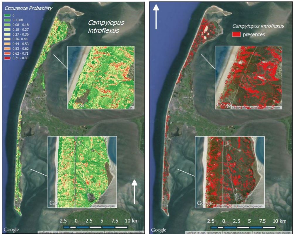
- the ability of airborne hyperspectral remote sensing data to generate reliable distribution maps of Campylopus introflexus, a non-native highly invasive moss species: link
- We successfully showed that our mapping methodology for IAS can be transferred to other areas, hence limiting the collection of additional field data: link
- a novel sampling design tuned to IAS in order to collect presence–absence data which can be use as input for species distribution models: link
- We demonstrated that LiDAR-derived data can be combined together with hyperspectral bands to model leaf nutrient content (nitrogen, phosphor) in the tree canopy at very fine spatial resolution (link) as well as we quantified the impact of Prunus serotina on structural and leaf chemical vegetation traits (link and link)
From science to the real life
What’s a bunch of research without bringing it into practice? That’s why we produced a free and open-access toolbox which aims at getting ecologists and stakeholders acquainted with the different outputs of the project: the DIARS toolbox!
This toolbox contains:
- open-source codes and tutorials to be used in the free and open source software (FOSS) R and GRASS GIS
- a new R package (cf. iSDM: https://cran.r-project.org/web/packages/iSDM/)
- a real case hyperspectral, LiDAR and field dataset designed to facilitate testing and training models
Beyond its undeniable scientific quality, DIARS had the foresight to anticipate the concrete use of its results by policy. By generating new free and open source tools and providing training, the project has definitively ensured the relevance of DIARS results to society.
Sonia Vanderhoeven (Belgian Biodiversity Platform)
Hence, the DIARS toolbox and its iSDM companion ensure a proper knowledge transfer that aims at engaging and educating our stakeholders and end users such as ecologists, nature conservation agencies and land managers.
Do you want to know more about DIARS? Have a look at the project website at http://diars.vgt.vito.be/
------------
Disclaimer: DIARS (Detection of invasive plant species and assessment of their impact on ecosystem properties through remote sensing) is funded by the ERA-Net BiodivERsA (SR/67/315), with the national funders: ANR (Agence Nationale de la Recherche); BelSPO (Belgian Federal Science Policy Office); and DFG (Deutsche Forschungsgemeinschaft). DIARS is a collaboration between VITO (coordinator), KU Leuven; Karlsruhe institute of technology; Friedrich-Alexander-Universität Erlangen-Nürnberg; University of Picardie Jules Verne and Fondazione Edmund Mach – Research and Innovation Centre.

/lewis-latham-0huRqQjz81A-unsplash.jpg)
/Land%20use%20model%20+%20green%20city.png)