
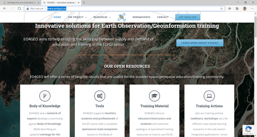
EO4GEO SKILLS ALLIANCE
EO4GEO is an Erasmus+ Sector Skills Alliance gathering, apart from VITO, 24 other partners from 13 EU countries, most of which are part of the Copernicus Academy Network. Be they from academia, public or private sector, they are all active in the education and training fields of the space / geospatial sectors.
“The collaboration between the public and private sectors on the one hand (demand) as well as the education system on the other (offer) is a key enabler of the mutual recognition of professional qualifications in the sector. The EO4GEO objectives align with the spirit of the Copernicus programme as it puts users in the driver seat.”
Emanuele Barreca, European Commission, Advisory Board member of EO4GEO
The project, which started in January 2018 and will finish in December 2021, aims to bridge the skills gap between the supply and demand of education and training in the space/geospatial sectors, fostering the uptake and integration of space/geospatial data and services in a broad range of application domains.
EO4GEO will not only support the Copernicus User Community but intends to reach to a broader audience, such as the Galileo user community, which can lead to synergies between different application domains where possible.
Within EO4GEO we work in a multi and interdisciplinary way and apply innovative solutions for its education and training actions:
- case-based and collaborative learning scenarios;
- learning-while-doing in a living lab environment;
- on-the-job training and co-creation of knowledge, skills and competencies.
VITO Remote Sensing is one of the contributing partners to the EO4GEO alliance, providing scientific content for the Body of Knowledge (BoK), training courses, an earth observation platform and a set of interactive tools for students, researchers, governmental and commercial bodies who are interested in gaining insights through earth observation.
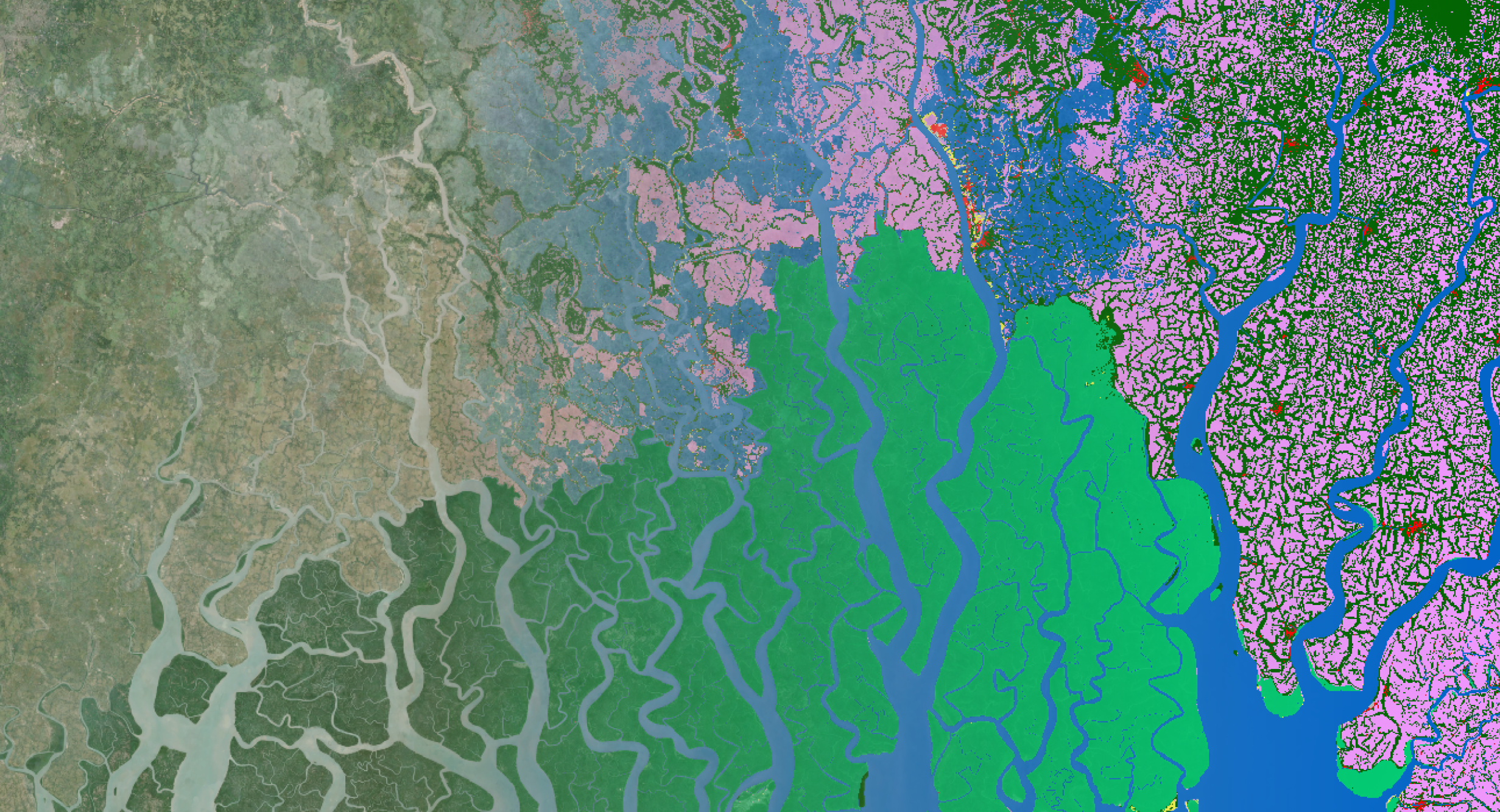
Exploring data and services via Terrascope
Within the EO4GEO project, VITO connects the EO4GEO community with the Terrascope platform to apply their knowledge and get started with the massive amount of Earth observation data and services available.
Terrascope is an online platform, making open-source satellite imagesof the European Copernicus programme easily accessible. It offers analysis ready data to all users, free of charge.
Everyone can discover the data and web services, create maps, animations and reports that help to make informed decisions. Terrascope allows users to explore EO data using worthwhile tools such as:
- Web services – protocols for downloading images and integrating them into GIS software
- Notebooks – programming environment to quickly access and edit data
- Virtual Machines – external computer used to view data and process it in the cloud
- Data access – direct access to satellite data
- EO viewer – free and open viewer to easily search, view, compare and download satellite data
The Terrascope team has prepared two trainings to help you get familiar with Copernicus satellite data and relevant image processing services. If you are new to this domain and want to get your hands on the data as soon as possible, start with the 'Accessing EO Data in Terrascope' training, which will soon be available through EO4GEO Training Portal. Once you have that under your belt and had a chance to do the hands-on exercises on Terrascope , you can take it a step further and indulge yourself in image processing. In 'Terrascope Application Development pack', soon we will show you step-by-step how to do a simple band math using Jupyter notebooks and OpenEO API on Sentinel-2 imagery.
Registering on Terrascope platform is free and easy. If you have an EduGAIN, COIH, Orcid, Academic or social media account, you can login without having to register!
Login now and take advantage of all the tools and resources that EO4GEO and Terrascope offer!
BODY OF KNOWLEDGE (BoK)
EO4GEO developed an innovative resource, describing an ontology for the EO/GI fields.
The existing Geographic Information Science and Technology Body of Knowledge (GI S&T BoK), developed by the GI-N2K project on the basis of the American University Consortium for Geographic Information Science, is the basis for the development and operationalization of the EO4GEO Body of Knowledge (EO4GEO BoK).
We describe the Geographic Information and Earth Observation domain by defining the underpinning inter-related concepts (theories, methods, technologies, etc.) that should be covered in education and training curricula.
COLLABORATIVE MINDMAP OF EO AND GIS
To develop the EO4GEO Body of Knowledge (BoK), the project team used the Living Textbook, a tool which helps to create a conceptual visualization of a knowledge domain and share it amongst educators, researchers and anyone who would like to understand that domain. It uses a concept map as a starting point and visualizes concepts and their relationships in one view, providing a convenient way to find connecting concepts and their descriptions.
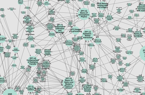
The EO4GEO BoK is developed to create and maintain a collaborative mind map/visualization of the domain of Geographic Information Science and Earth Observations, which allows users to create, edit and find concepts.
The EO4GEO BoK is open and alive. A group of experts is continuously working on it and it is built in such a way that web applications can reuse the information via web interfaces. In this way, web application developers can create their own application on top of this information.
Visualization and Search
If you want to view a structural representation of EO/GI concepts and dive deep into it, you can visit BoK Visualization and Search tool.
The BoK Visualization and Search tool allows users to navigate and visualize the EO4GEO Body of Knowledge (BoK) in a graphical and textual way.
Starting from higher level concepts, representing areas of knowledge in the field, one can browse down to more detailed concepts.
Each concept has a permanent URL to easily refer to it, a description, relationships to other concepts and associated skills. Previous versions of each concept can also be browsed, and an advanced search is available to search in concepts and their fields.
BoK will have release cadence of three months, therefore you can expect regular updates. If you would like to contribute to the development of BoK, join the network of experts and be acknowledged for your contribution.
Training portal
As training is vital in acquiring skills, EO4GEO alliance provides material on various topics for different types of audience which are also intended to be a valuable instruction resource for educators. This content will soon be publicly available through the training portal. Stay tuned!
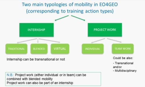
Mobility programme
One of the advantages of having a large alliance is the availability of vast resources that can be leveraged to support the bigger goal - that is to bridge the skills gap in the space/geospatial sector. For this purpose, EO4GEO offers a mobility programme for students and young professionals to promote work-based learning through internships and project work by several private and public sector partners.
You'll find different types of mobility options within EO4GEO, such as blended and virtual, making it possible to overcome practical implications of COVID-19 crisis where a traditional mobility may not be possible in the mid-term.
The EO4GEO Mobility Programme will be available until the end of 2021.
Keep a good eye on the catalog and on the EO4GEO website, you might even find opportunities at VITO Remote Sensing!

/lewis-latham-0huRqQjz81A-unsplash.jpg)