Ecosystem accounting in Europe
In March 2021, the United Nations of Statistical Division (UN-SD) adopted the System of Environmental Accounting – Ecosystem Accounting (SEEA-EA) as the international statistical standard for ecosystem accounting. This standard provides a statistical framework to organize data about habitats and landscapes, and measure the ecosystem services through linking this information to economic and other human activities. The European Commission, led by Eurostat, has proposed an amendment of the EU Legislation 691/2011 on environmental accounts, based on this standard, to mandate among other things the regular production of ecosystem accounts in all 27 EU Member States.
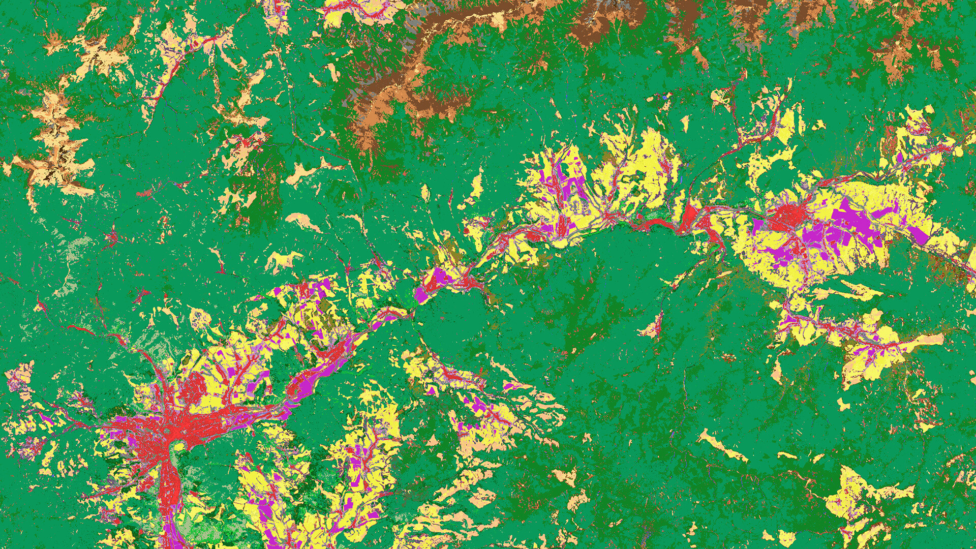
Ecosystem services of the INCA Tool (image adapted from Eurostat INCA, inset image from UNSD SEEA EA)
Contrary to other environmental accounts (SEEA – Central Framework) which only use statistics or non-spatial datasets, this new standard of Ecosystem Accounting requires a geospatial approach to provide biophysical information about ecosystems, measuring their services and track their changes. Ecosystems function differently depending on where they are, their capacity to supply services depends on their location and accessibility. Integrating spatial and non-spatial data, typically through the use of Geographic Information Systems (GIS) and geospatial models, is therefore crucial to provide accurate and objective ecosystem accounts. Earth Observation geospatial datasets are an important source for these accounts.
Next to the standard Supply and Use accounting tables, ecosystem accounts also provide geospatial information as maps. These maps inform policymakers to take better decisions at local to regional level to support the development goals and biodiversity strategy. The accounts provide a range of information and sustainability indicators about:
- provisioning services (goods that can be extracted from ecosystems)
- regulation services (regulation of processes as climate, soil, hydrological cycle)
- cultural services (the non-material benefits provided by ecosystems)
Despite ecosystem accounting has grown over the last years as an emerging field, compilation of the accounts requires still substantial investments by public bodies as statistical offices and environment agencies.
INCA tool first public release
The INCA tool that we (VITO Remote Sensing) developed under a contract with Eurostat, the statistical office of the EU and in collaboration with the Joint Research Center (JRC) supports the generation of ecosystem services accounts in a systematic way and can be applied at regional, country or continental level in Europe. The models are based on the INCA models. These models are originally developed by the Joint Research Center (JRC) and further refined to comply with the proposed EU legislation on ecosystem accounts. The INCA tool includes distinct ecosystem service models designed for terrestrial and freshwater ecosystems, as well as support to do standard geoprocessing in statistically compliant manner – Account Ready Data (AccoRD).
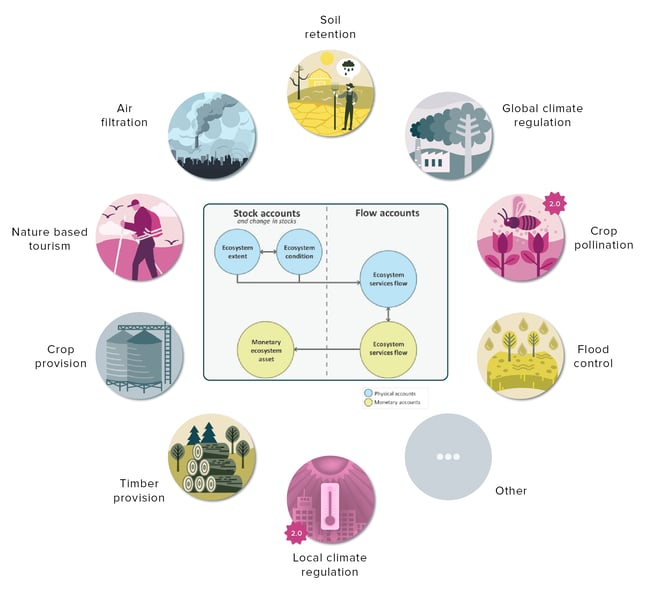
The INCA tool provides a set of nine spatially-explicit models using geospatial maps and statistical tables as information sources. Seven models are already available and 2 more will be added by the end of this year. The INCA tool produces European standardized accounting tables and maps in biophysical terms (i.e. tons of carbon sequestered) assigned to the ecosystem typology developed for the European continent (see figure) or in economic terms (i.e., euros).
Ecosystem typology as implemented in INCA Tool derived from CLC accounting layers for 2018 (EEA). - © boundaries from EuroGeographics
One of the main benefits of the INCA tool is that it does not require advanced programming skills (Python3, GDAL). Thanks to a QGIS plug-in you can generate ecosystem accounts with some basic GIS software skills. Furthermore, the tool is modular in the sense that users can select their ecosystem service(s) of interest and integrate their own national or regional datasets. The decoupling of input data (data areas) from the reporting areas (accounts) enables users to generate statistical Supply-Use tables in order to address questions at local, regional or national scale.
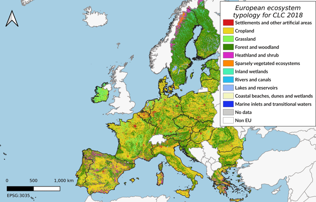
Left: INCA tool interface for global climate regulation service - Right: geospatial account for Belgium-Netherlands-Luxemburg (upper is carbon stock, lower is carbon flux). - © boundaries from EuroGeographics
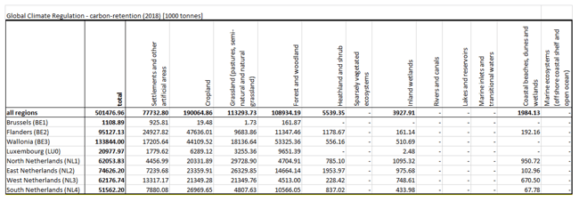
Result from INCA Tool : Supply table account for Belgium-Netherland-Luxemburg on carbon stock (retention) at regional level
Multi-level use
The INCA tool is developed according to the FAIR principles and targeted to be used from novice to expert users. Novice users only need some basic GIS skills to run the models as explained above. More experienced users can use the code and adapt the models. They can automate the execution of the models from a shell (e.g., account for multiple years) or integrate the Application Programming Interface (API) in their national accounting system. The shell includes additional settings that are not available in the user interface, e.g. exploratory models to calculate the monetary valuation.
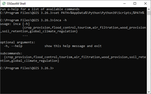
Example of shell command interface
what's next?
A first version of the INCA tool is available and additional ecosystem service models will be added later in an updated version (release 2). The tool will also be used through its shell interface to extend the EU-continental accounts, generating a new series over the period 2000 to 2021.
These models will be enhanced in the coming years. By means of the ever-growing new geospatial datasets, the experience gained and progressive insights in ecosystem service accounting we will also extend the INCA tool by adding new models.
As the tool is released under the GPL license, we also aim to integrate the INCA models into the ARIES for SEEA Explorer web platform using Artificial Intelligence for rapid natural capital accounting. This integration will be explored as part of the European Space Agency (ESA) Pioneering Earth Observation Applications for the Environment (PEOPLE-EA) project. The project will also simplify and unify the integration of large Earth Observation datasets via the openEO interface.
The INCA tool is a first milestone to fully support ecosystem account measurement and reporting for all member states and to accelerate the transition the a more sustainable planet/future.
This work was conducted by a consortium led by VITO, as a contractor for the European Commission – Eurostat under contract n°2020.0318, and in close cooperation with the INCA experts from the Joint Research Center and the European Environment Agency.