Serving the potato sector for more than 5 years already
In 2022, WatchITgrow will be serving the potato sector in Belgium, The Netherlands, France and Germany for 5 years already. In these 5 years, the platform has changed from a yield prediction and monitoring tool for the Belgian potato market towards an open and holistic platform that supports the agricultural sector in maintaining its growth whilst at the same time improving its sustainability.
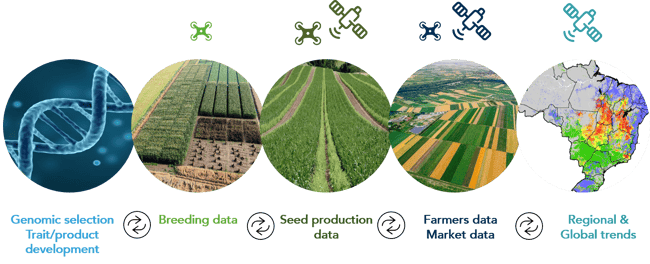
Throughout the years WatchITgrow shifted its focus towards creating a so called 'digital twin' of any field. By combining all possible data sources (satellite, weather, soil, field, machinery data, …) and using new technologies such as big data analytics, machine learning, etc., WatchITgrow provides farmers with more personalized advice which allows them to sustainably increase their yields.
A shift from traditional simulations to big data models
The digital transformation has reached nearly every aspect of society and business, including of course the agricultural food system which is adopting at a rapid pace. Digital innovations offer the potential to drastically improve yields, sustainability and farmers income.
To support this digital transformation we also need to shift from traditional crop growth simulation models to big data models. To train these models large amounts of field data are needed. The base data layer for every field remains the satellite derived information. These objective measurements deliver us information over time on the growth and health of the crops on the field, as influenced by crop species/variety and agro-ecological conditions such as soil type, nutrients, and local weather.

Remote Sensing driven data science for the Agro-Food sector
The magic is in the mix of the data
Now, if we can complement this satellite derived information with objective data like up-to-date meteorological data, soil data, management practices, actual yields, etc., we can really start to train big data models and identify in an objective way which are the best possible actions for any given field, with all its specific characteristics, its specific history, etc.
A steady influx of high quality reliable data is thus extremely important. WatchITgrow has therefore chosen to become an open platform and invites all interested parties to link and cooperate around this sustainability mission.
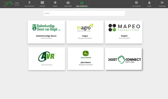
WatchITgrow already collaborates with research institutes like INAGRO and ILVO, offers services from the Soil Service of Belgium, and exchanges data with professional manufacturers of agricultural machines like AVR and John Deere. By expanding this network we can keep improving the data models which are needed to offer more personalized and specific information about any given field.

In order to further facilitate data sharing among various existing platforms and tools, while safeguarding data ownership, WatchITGrow is now also connected with the DjustConnect data hub. The collaboration with DjustConnect allows farmers to keep a comprehensive overview on all of their data and allows them to easily manage with whom they share certain data and when.
This not only gives them more control, but also reduces their administration, allowing the growers to spend time on what matters most to them, which is increasing their yields to secure their position in the agricultural market and a better income.
Continuous innovation remains essential
By collaborating with various research institutes, it’s now possible to further build on scientific results we obtained from research projects. Earlier this year WatchITgrow for example launched the ‘WaterRadar’ hereby connecting farmers that need water for irrigation with potential water suppliers in a search radius around the field. Farmers can also access information about soil fertility in Flanders at municipality level via WatchITgrow. This information is derived from soil analyses performed by the Soil Service of Belgium and includes information on the content of pH, organic carbon, phosphorus, potassium, magnesium and calcium of the soil.
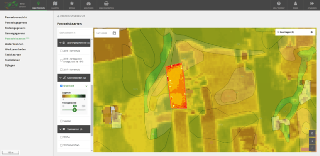
In addition to the greenness (fAPAR) maps, WatchITgrow also provides now historical variability maps or “yield potential maps”. These maps give a good indication of the (historical) performance of a field and can be used to assess the quality of fields, as a field selection tool before the season or as input for variable rate applications.

Printscreen of the WatchITgrow platform
WatchITgrow in 2022 and beyond ...
In 2022 and beyond we will keep on building partnerships with all interested parties and WatchITgrow will continue its efforts to support farmers and industry in the transition towards a sustainable agriculture as set forward by the rules of the European Green Deal.
Contact us if you wish to receive more information about WatchITgrow and DjustConnect, and how you can monitor your crops and exchange data in a digital, safe and controlled way.


/Blog_WorldCereal_1200x650.png)
/lewis-latham-0huRqQjz81A-unsplash.jpg)
/background_image_blog.jpg)