UPDATE 21 September 2023:
On September 21, 2023 Nature Food published the paper 'Dynamic global-scale crop and irrigation monitoring' (See, L., Gilliams, S., Conchedda, G. et al. Dynamic global-scale crop and irrigation monitoring. Nat Food 4, 736–737 (2023)). Together with colleagues from IIASA, ESA, Stellenbosch University, and the Food and Agriculture Organization of the United Nations (FAO) we highlight the importance of the continuation of WorldCereal beyond its showcase year 2021. The WorldCereal system demonstrates the power of integrating remote sensing, machine learning, and shared reference data to offer critical agricultural information for food security. WorldCereal has the potential to include more crop-specific data, thereby boosting the accuracy of subnational and national agricultural statistics. The authors explain the importance of further expanding this groundbreaking research and operationalizing WorldCereal to achieve the Sustainable Development Goals (SDGs). ESA and VITO are currently looking into the possibilities to further expand WorldCereal.
Towards seasonally updated global crop maps
The ESA WorldCereal project started in June 2020 with the ambitious goal to develop an efficient, agile and robust EO based system to support global cropland monitoring services. Achieving food security for all is a major challenge in the face of population growth and climate change. One of the first steps is to know which crops are growing where and how – each season. WorldCereal would need to be an opensource system that is able to create seasonally updated global cropland, crop type and irrigation maps at 10 m resolution. During the first months, the WorldCereal team focused on the engagement with the community and collection of in situ data for calibration and validation. In parallel the WorldCereal system was designed and several algorithms were compared taking into account different parameters including speed, quality, the need for training data, spatial consistency, etc.
In the beginning of 2022 the WorldCereal team was ready for the next step in the process, the large scale demonstration. WorldCereal’s algorithms were trained on part of the available in situ data and demonstrated on five areas (1,5 M km², parts of Argentina, Spain, France Ukraine and Tanzania) that were selected in collaboration with the WorldCereal Champion users (GEOGLAM, FAO, AMIS). More about the validation approach and insights in the validation of the products can be found in our previous blog ‘Global seasonal crop mapping: from validation to demonstration’.
Now, 2,5 years after the official kick off, the WorldCereal team is proud to release the world’s first dynamic and open-source system to provide seasonally updated cropland and crop-type maps at 10-meter spatial resolution at global scale. Time to discover more about the production and use of this detailed view to help monitor agricultural production across the world.
First seasonal updated cropland map for 2021
The global production phase
In Autumn 2022, as soon as we knew that the demonstration products met the requirements set out by the international user community, we started the production of the seasonal updated crop products. The WorldCereal products are based on open and free data from the Copernicus Sentinel satellites and the USGS’ Landsat satellites.
Unfortunately, the start of the global production phase coincided with the loss of Sentinel-1B. Since the algorithms were trained and tested on both Sentinel-1 A/B and Sentinel-2 A/B, the WorldCereal team had to investigate the impact and see what is the best way to proceed. In collaboration with the user community and ESA, the decision was taken to target on the 2021 season and not demonstrate the system near real time (NRT) for the 2022 season as originally planned. As such no new validation data sets could be collected and validation needed to be done based on for 2021 available data.
Collecting validation data was a tremendous challenge but by using Geo-Wiki and the international community, the consortium was able to succeed. The cropland products are reaching the required overall 80% accuracies and for crop type we are reaching 70%. However, it is clear that these are overall figures and that accuracies are very region dependent. Main driver of the accuracy is the availability of good quality in situ data over several years.
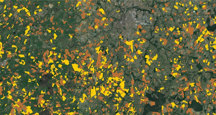
Zoom of crop type maps (yellow mais, brown cereals) in France
WorldCereal Seasonal products
The trigger to start updating the WorldCereal seasonal products is the End of Season of an agro-ecological zone (AEZ). In discussion with end users and based upon existing crop calendars from EC-JRC and GEOGLAM Crop monitor three major growing seasons were defined: winter, summer 1 and summer 2 (Franch et al, 2022). The WorldCereal system builds a hierarchy of seasonally-updated layers.
The first product is a base layer of an temporary crops which shows all temporary cropland areas in a specific zone over a 1 year period. Next to this annual product, WorldCereal provides several season-specific products including maize, winter cereals, spring cereals, active cropland and active irrigation.
- Temporary crop winter cereals: active cropland layer, active irrigation and winter cereals
- Temporary crop maize main: active cropland, active irrigation, spring cereal and maize
- Zones that have a temporary crop maize second season: active cropland, active irrigation and maize
These seasonal updated products per AEZ support end-users like UN-FAO, GEOGLAM, AMIS, NGO’s, Ministries of agriculture etc., in analyzing agricultural production and food security. Because of the global nature of the WorldCereal products, such analyses are no longer restricted to dedicated countries/zones, but can now be extended to data-sparse regions to get a global picture of maize and cereal production across different growing seasons.
Monitoring agricultural situations across the world
The WorldCereal consortium demonstrated the feasibility, with the current state of the art and based on the currently available open data sets, of producing seasonally updated cropland and crop type maps at global scale. The used algorithms are demonstrated to be robust over space and time. The overall accuracy of the system is meeting end-users’ requirements, but it has to be noted that accuracy is very region dependent. Main driver of this accuracy is the quantity and quality of in situ data. Users are therefore invited to contribute to the system’s global in-situ database. This spatially-specific agricultural information will help monitor agricultural situations across the world.
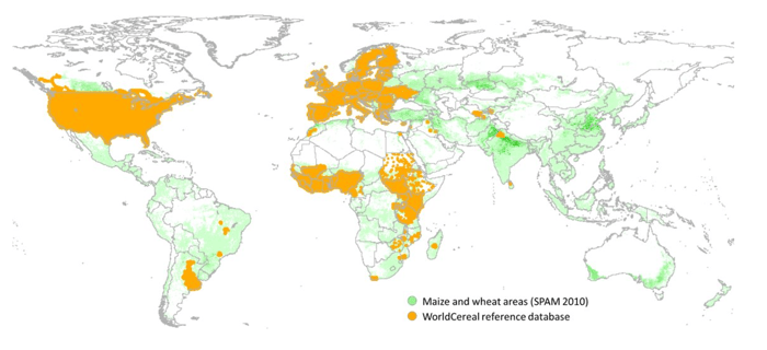
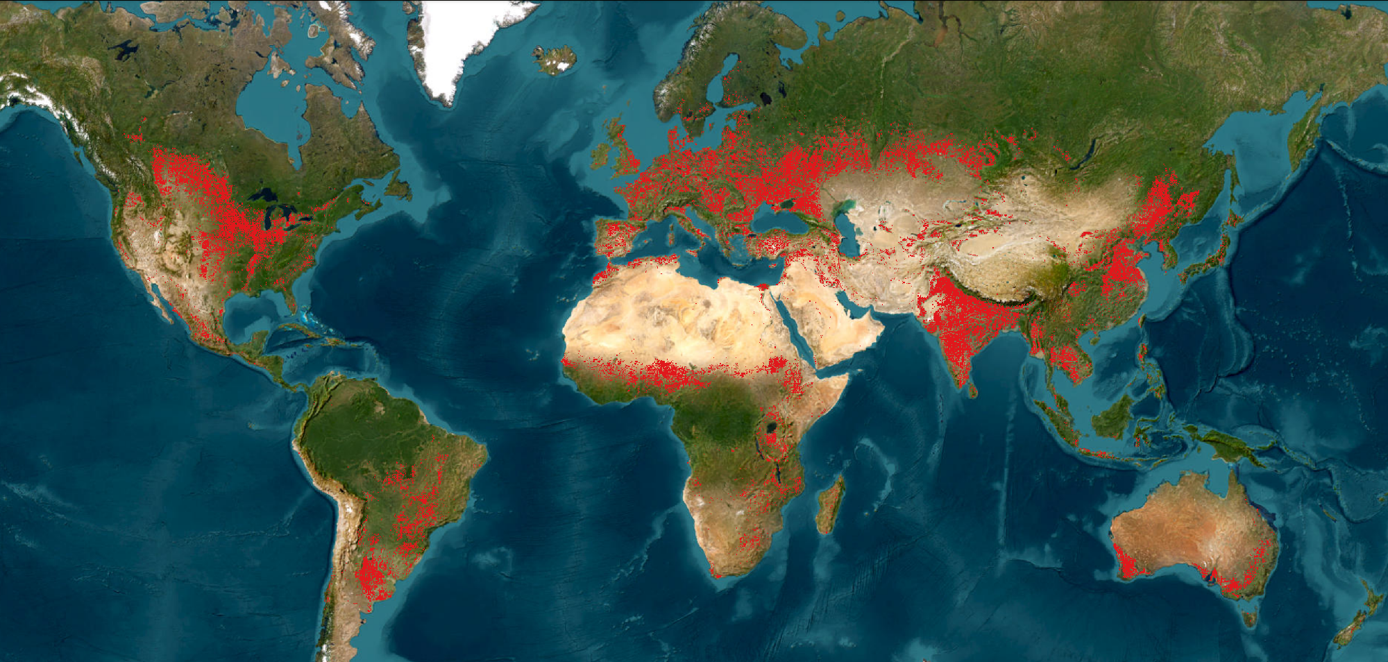
Overview of all data in WorldCereal reference database of November 2022
For cropland this lack of in situ data can be compensated by visual interpretation of HR data and time series of satellite data, for crop type this is much more difficult. Hence, next to improving early warning systems and global crop condition assessments, the accuracy results of the WorldCereal system could drive the GEOGLAM community on prioritizing areas for in situ data collection.
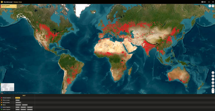
WorldCereal is more than just maps, it’s an opensource system. Next to the products the source code and the system is available on github. Discover the WorldCereal products via the interactive map.
![]()

/Blog%20Post%20Strip%20Cropping%20-%20Featured%20Image%201200x650%20150%20ppi.png)
/Blog_WorldCereal_1200x650.png)
/lewis-latham-0huRqQjz81A-unsplash.jpg)