Taking hyperspectral science to the sky

By Kristin Vreys 27 June 2017

Airborne remote sensing is more than just ‘put a sensor on a plane and fly’.
A successful airborne data acquisition campaign relies on recurrent instrument calibration, careful mission planning and execution. Then the data needs to be processed. Let me tell you how we do it after 7 years of APEX flight campaigns and image processing services.

APEX, a trusty and high-quality hyperspectral sensor

APEX (Airborne Prism EXperiment) is a high spectral and spatial resolution hyperspectral sensor developed by a Swiss-Belgian consortium for the European Space Agency. It acquires data for 1000 across-track pixels, in up to 533 spectral bands ranging from 380 to 2500nm.

We have been operating APEX together with the Remote Sensing Laboratories (RSL) of the Zurich university since 2010, covering about 130 areas in 12 different European Countries over the past 7 years.
Most of the APEX data is acquired through group shoots, during which data for several users is acquired in one flight campaign of a few weeks.

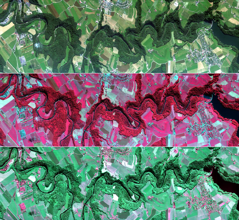
SARIN_a01_RGB_CIR_CHC_Mosaic_Horizontal-1.pngAPEX images (CHC, CIR, RGB) of the river La Sarine flowing into Gruyère Lake (Switzerland) © RSL


Hyperspectral data for Earth science

After the flight campaigns, our image processing experts take over. They make sure the data is corrected for radiometric, geometric and atmospheric effects so that you can access reliable and high quality data.

APEX data serves a wide range of applications:

  • agriculture and horticulture monitoring
  • soil characterization
  • glacier snow and ice characterization
  • biodiversity assessment
  • urban ecosystems
  • aquatic applications
  • atmospheric NO2 retrieval
APEX data is also used for inter-calibration activities with other airborne and spaceborne sensors.
 
A multitude of Belgian and European researchers, institutes and agencies including the European Space Agency (ESA), the European Facility For Airborne Research (EUFAR) and the Belgian Science Policy Office (BELSPO) use APEX data.

Operator3_Johan.pngAPEX operator onboard D-CODE © VITO Remote Sensing


Like this article? Share it on
Kristin Vreys
An article by
Kristin Vreys
Senior R&D Professional
More info about Kristin Vreys
Share

Related posts

Validation of iCOR for Sentinel-3 over land surfaces and new SNAP plug-ins
  • Image Processing ,
  • atmospheric correction ,
  • iCOR ,
  • Sentinel-3 ,
  • SNAP

Validation of iCOR for Sentinel-3 over land surfaces and new SNAP plug-ins

By Erwin Wolters 10.05.2021

After releasing the iCOR plug-in for Sentinel-3 Ocean and Land Colour Imager (iCOR4S3) in 2019, a thorough validation was performed using among others the..

Lees meer
APEX, from simulator to operational hyperspectral system
  • Hyperspectral ,
  • Camera & Sensor ,
  • APEX ,
  • calibration ,
  • validation

APEX, from simulator to operational hyperspectral system

By Bart Bomans 25.11.2019

APEX is an airborne hyperspectral instrument. It was originally intended to serve as a simulator and a calibration and validation device for spaceborne..

Lees meer
Flexible cloud processing with OpenEO
  • Image Processing ,
  • Data Cubes ,
  • Cloud Processing ,
  • OpenEO

Flexible cloud processing with OpenEO

By Jeroen Dries 03.10.2019

While more and more platforms to process EO data become available, it is getting increasingly hard to choose which platform is best suited to process your..

Lees meer