
iCOR4S3 on ESA's G-POD facility
In order to process huge amounts of Earth observation data, the European Space Agency (ESA) provides the Grid Processing on Demand (G-POD). The G-POD is a generic operational processing environment where specific data handling applications can be plugged into seamlessly.
Since late 2019, G-POD also facilitates an iCOR4S3 processing service, based on the iCOR version that is available as a SNAP plug-in. This service eliminates the need to download the input Level-1 data and allows users to perform iCOR4S3 batch processing on OLCI scenes, automatically selected based on an Area of Interest (AOI) and time period. Access to ESA’s G-POD facility can be requested via eo-gpod@esa.int and a condensed iCOR4S3 User Manual is available here.
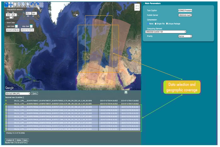 The iCOR4S3 User Interface on the G-POD
iCOR4S3 validation over land surfaces
In a previous blog 'Atmospheric correction software for Sentinel-3', we showed that iCOR for Sentinel-3 performs well over inland waters and coastal zones. Now, we performed an iCOR4S3 validation over land surfaces using various reference data. The validation was carried out on retrieved Aerosol Optical Thickness (AOT) and surface reflectances obtained from the OLCI Level-1 Top-of-Atmosphere (TOA) reflectances for January – September 2019. We processed 389 OLCI scenes on the G-POD, distributed over five geographical Regions of Interest (see the figure below). In total, 577 GB were processed using the standard iCOR4S3 settings, see our online User Manual. The resulting AOT and surface reflectances were downloaded for further post-processing and validation.
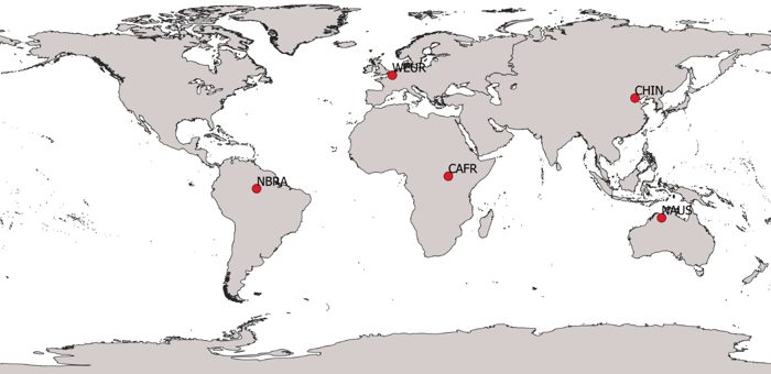 The five Regions of Interest (RoI) for which iCOR4S3 AOT, surface reflectance, and Vegetation Indices ere validated.
iCOR4S3’s retrieval quality was assessed for Aerosol Optical Thickness (AOT), surface reflectance, and Vegetation Indices (VIs) retrievals, using three reference datasets:
- Aerosol Robotic Network (AERONET) AOT, as well as surface reflectance simulations using AERONET-observed AOT and Total Column Water Vapor (TCWV) as input
- Radiometric Calibration Network (RadCalNet) surface reflectance observations
- Sentinel-3/OLCI SYN Level-2 data (SYN L2), provided by our partners of ACRI-ST (France)
The validation reveals that iCOR4S3 provides accurate and consistent results in comparison with the AERONET-based and RadCalNet reference data. The retrieved AOT time series are much smoother than those of SYN L2. Also for surface reflectance and Vegetation Indices (VIs) the iCOR4S3 time series appear smoother than SYN L2, but to a lesser extent. These results are condensed in the figure below, which expresses the Time Series Smoothness Index (TSI, Claverie et al., 2018), for which lower values indicate smoother timeseries. The higher iCOR4S3 AOT temporal smoothness compared to SYN L2 is clearly visible from the lower TSI values in the boxplot in (a), while (b) and (c) show that the higher AOT temporal smoothness only leads to limited improved iCOR4S3 smoothness over SYN L2. We suspect this dampening being the result of limited AOT impact on the atmospheric correction relative to the applied aerosol model impact for iCOR (rural) and SYN L2 (continental).
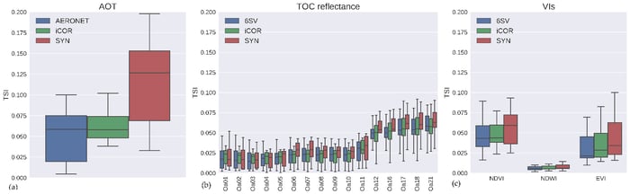 TSI boxplots for (a) AOT, (b) surface reflectance, and (c) Vegetation Indices (VIs). Results were obtained for 11 AERONET sites and 4 aerosol models.
For more detailed results I refer you to our journal paper ‘iCOR Atmospheric Correction on Sentinel-3/OLCI over Land: Intercomparison with AERONET, RadCalNet, and SYN Level-2’.
New iCOR SNAP plug-ins for Sentinel-2, Sentinel-3 and Landsat-8
Additional to the iCOR4S3 land surface plug-in that we introduced and in order to stay compatible with the latest SNAP 8.0 version, we also developed new iCOR plug-ins for Sentinel-2 and Landsat-8. These new SNAP plug-ins are up-to-date with internal developments carried out for the Atmospheric Correction Intercomparison Exercise II (ACIX-II). Within this framework, iCOR’s retrievals on Sentinel-2 and Landsat-8 observations over rivers, lakes, and coastal zones were extensively validated and showed good quality. More information about this validation can be found in the recent publication ‘ACIX-Aqua: A global assessment of atmospheric correction methods for Landsat-8 and Sentinel-2 over lakes, rivers, and coastal waters’.
During the developments we also took into account our users’ feedback. The new iCOR SNAP plug-ins include the following improvements:
- the use of Sentinel-2 angle information at pixel level
- a sun-glint correction over water
- the possibility to use a desert aerosol model instead of the default rural model
- image-based water vapor retrievals for Sentinel-2 over land
- the option to apply radiometric gains prior to the atmospheric correction

Does this mean our work is completed? Of course not! We will keep on improving and releasing new user-friendly iCOR plug-ins. Upcoming developments involve the possibility to include additional aerosol models, as well as including Copernicus Atmospheric Monitoring Service (CAMS) AOT data for cases in which the AOT retrieval does not succeed, using a similar approach as for iCOR on Sentinel-2/Multi Spectral Imager (MSI). Stay tuned for more!


.png)