iCOR, atmospheric correction made easy
Mid-2017 we were proud to launch the iCOR plugin for Sentinel-2 and Landsat-8.
iCOR is a scene generic tool for atmospheric image correction. The version for Sentinel-2 and Landsat-8 was made available to the broad user community through the ESA Sentinel Application Platform (SNAP). With more than 700 registered users we keep on improving iCOR and expanded the software for multiple sensors including e.g. PROBA-V and drone data.
Six months after the launch of iCOR, we also kicked off the iCOR4S3 project. Under the authority of ESA, we adapted iCOR to atmospherically correct Sentinel-3 data and performed a thorough validation of the software. After a year of hard work and thanks to a number of people who provided us field data for validation we are happy to launch the Sentinel-3 plugin for the Sentinel toolbox (SNAP)!
A harmonized correction with Sentinel-2 will allow
to exploit and combine the higher spatial information from Sentinel-2 with the richer spectral information
from Sentinel-3.
Steffen Dransfeld - Sentinel-3 Optical Data Quality Manager, ESA
iCOR for sentinel-3
The iCOR version for Sentinel-3 is now freely available to perform atmospheric correction for land and for coastal, transitional and inland waters. Thanks to the distribution of the plugins, you are now able to use the same atmospheric correction for Sentinel-2, Landsat-8 and Sentinel-3.
iCOR for Sentinel-3 OLCI is a modified implementation of the ICOR approach as already implemented in SNAP for the correction of Sentinel-2 and Landsat-8 (De Keukelaere et al.; 2018)
Aerosol Optical Thickness (AOT), an input parameter for the atmospheric correction, is retrieved from the land as described in De Keukelaere et al. (2018) but with some additional constraints added for OLCI over water areas.
The SIMEC adjacency correction is also implemented and the user can decide to turn it on or off. More information about the methodology can be found in the manual of the plugin.
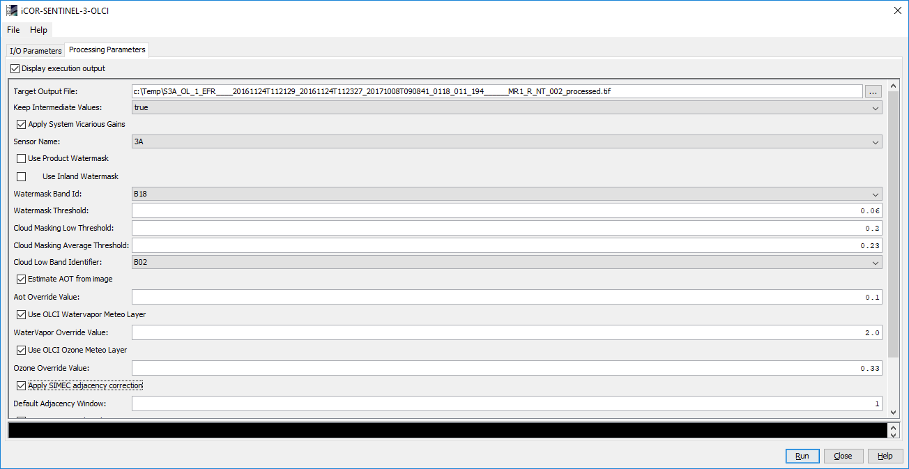
Screenshot iCOR for Sentinel-3 SNAP plug-in
What's in it for you?
iCOR can be applied to both water (inland, transitional and coastal) and land surfaces. The plugins allow you to use the same atmospheric correction for all surfaces. Do you want to compare or fuse Sentinel-2 with Sentinel-3 data? You can use iCOR for both sensors.
For inland waters, the performance of iCOR was compared against the marine baseline atmospheric correction which is currently provided in the OLCI Level2 marine products.
iCOR exceeds the performance of the current atmospheric correction for lakes. The adjacency correction SIMEC further increases the performance!
Steffen Dransfeld, Sentinel-3 Optical Data Quality Manager at ESA, explains how iCOR supports the remote sensing community: "With the iCOR4S3 project we have managed to provide the optical remote sensing community with an interest in inland water bodies and coastal zones with a processor to perform an atmospheric correction of a higher level accuracy than is currently done in the operational Sentinel-3 water-leaving reflectance products for those zones.
Moreover a harmonized correction with Sentinel-2 will allow to exploit and combine the higher spatial information from Sentinel-2 with the richer spectral information from Sentinel-3."
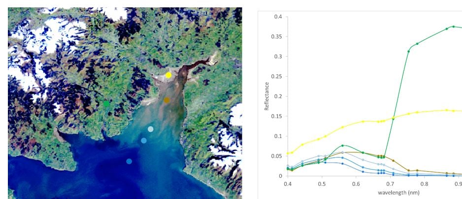
Subset of OLCI image processed with iCOR (left) - extracted land and water reflectance spectra (right)
Download in just a few clicks
The iCOR plugin can be freely downloaded in just a few clicks. After download and installation you can open the software as a plugin in SNAP. More detailed instructions on how to install and use iCOR can be found in the user manual.
Are you interested to discover more and get started as quickly as possible? You can request a professional iCOR training and receive tailored advice on how to use iCOR in your daily operations.
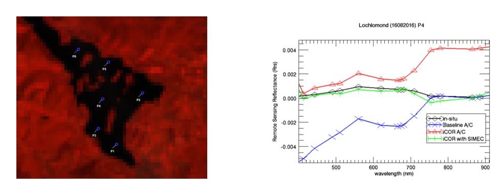
OLCI Colour-Infrared subset Loch Lomond, Scotland (left) | remote sensing reflectance (right - black: in-situ, red: iCOR, green: iCOR with SIMEC, blue: baseline marine A/C)
iCOR for Sentinel-3 was developed through funding from ESA with special thanks to Brockmann Consult for their support in developing the SNAP plugin. We also want to thank CNR-IREA, the University of Stirling, Klapeidos university, Tartu Observatory and the university of Cape Town for providing us with valuable field data.
.
------------------------
Interested in more?
We also support iCOR for other sensors and data e.g. PROBA-V, drones, etc. or even tailor the iCOR software to optical multispectral and hyperspectral sensors.
Feel free to contact us if you want to use iCOR to improve your image quality.
![]()

/lewis-latham-0huRqQjz81A-unsplash.jpg)
/boudewijn-huysmans-_iyh6g5KHQA-unsplash.jpg)