In pursuit of the best seeds
With the rapid advance of drone-based imaging technologies, seed breeding companies get the ability to automate various manual processes. Gathering accurate and extensive data always remains very important to maximize the success of experimental field trials, but it is also often limited by both costs and the availability of trained field workers. But what if we improve data gathering, processing and analysis with less effort and costs? Via MAPEO, our a modular and customer-centric remote sensing platform, we provide seed breeders automated workflows which allow them to automate and simplify repetitive and costly tasks such as counting plants and identifying gaps in field trials. This innovative drone-based phenotyping solution will help seed breeders not only save time and money, but also obtain more accurate data to support their search for more sustainable crop varieties.
Through an ongoing partnership with seed breeding company SESVanderHave and thanks to the Sense of Field project funded by VLAIO, we've developed a workflow which not only counts crop gaps, but also analyses the gaps in surrounding crop rows to automatically generate statistics
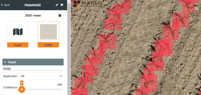
Counting plants in the field
The first assessment of different crop phenotypes in field trials is whether they germinate in the trial plots after planting. This is a vital question for seed breeders: what proportion of each crop variety being studied grows in the field? Normally such a question would be answered by manual counting of plants: an arduous and costly process that is also subject to human error. Through the MAPEO platform, we have used drone imagery and artificial intelligence to automate plant counting in experimental trial fields.

Automatically detecting crops in an experimental field
Using MAPEO, seed breeders can upload imagery from the initial stages of plant growth and get an accurate count of the crops in your trial fields. Even more relevant, using built-in tools in MAPEO, breeders can analyse the crop count per trial plot, opening the doors for comparative analysis and statistics in the search for the most promising varieties. By automating this normally lengthy process, drone-based assessments bring value to breeders by reducing their costs and providing comparable and automated results across trial fields around the world. But besides creating a more efficient workflow for seed breeders and data scientists alike, the plant count product has become the steppingstone for further innovative products in MAPEO, like the gap count.
Identifying crop gaps
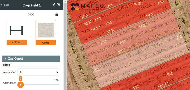
Apart from counting the number of growing crops in experimental plots, seed breeders also want to know the number of missing crops, as well as their location. This information can be useful to identify the least successful crop varieties, but also to assess nutrient and water usage for surrounding crops. Large gaps where crops should be growing can affect the growth rates and yield of surrounding crops, leading to bias and miscalculations. 
Counting the size of crop gaps in the field
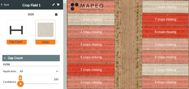
With MAPEO, we have made it easy to not only calculate crop gaps in experimental plots, but also to assess the gaps in surrounding plots. This additional information can make it easier for data scientists to understand whether there is any bias in yield data due to a lack of competition for nutrients from surrounding crops. After delineating their experimental plots, users can directly download both crop counts and crop gap assessments from MAPEO on a plot-level.

Counting the number of missing crops in each trial field
The gap count feature is one of the many new features being developed in MAPEO for plant phenotyping applications. Other features under development include field heterogeneity and drought stress indices for crop applications.
We work together with seed breeders to bring forward new products that are innovative and improve efficiency by automating the costly manual tasks. Drones offer an excellent alternative to manual counting, and MAPEO can offer this alternative as a part of our processing services. With the field of drone imagery continuing to grow rapidly, innovative new features such as the plant count and gap count will be at the forefront of MAPEO services for plant phenotyping.
Ready to get started?
Want to know more? You can now access the new MAPEO Help Center to find more information about the MAPEO applications and features, how to get started, downloads, and helpful articles. If you want to get in contact with MAPEO experts, you can reach us by sending an email to support@mapeo.be. You can also request a MAPEO demo account which gives you access to pre-loaded imagery to familiarize yourself with MAPEO’s many features.
You can also talk with our team about custom applications of MAPEO, including creating new features and new approaches to get the most out of your datasets. If you would like to learn more about MAPEO in person, you can find our experts at the upcoming events below:
- International Plant Phenotyping Symposium in Wageningen (NL) from 27-30 September 2022
- Seed meets Technology in Zwaagdijk-Oost (NL) from 27-29 September 2022
- Euroseeds congress in Berlin (DE) from 24-26 October 2022


/Blog_WorldCereal_1200x650.png)
/lewis-latham-0huRqQjz81A-unsplash.jpg)
/background_image_blog.jpg)