
ESA WorldCover's cardinal requirements
Monitoring global land cover changes is essential in managing the Earth's natural capital such as soils, forests, water resources and biodiversity. Given the changing state of this natural capital, the need for timely, accurate and high resolution land cover information is more pressing than ever.
As outlined in my previous blog ‘Towards a global land cover map at 10 m resolution’, the European Space Agency initiated the WorldCover project to answer to this need. With an amazing team of highly experienced remote sensing experts, EO researchers and data scientists, covering all relevant aspects of land cover mapping we kicked-off ESA WorldCover on August 27, 2019 to provide a new global baseline land cover product for 2020 in almost near-real time with the following cardinal requirements:
- Produce a validated global land cover map at 10 m resolution
- Deliver as fast as possible after the last data acquisition
- Include a minimum of 10 land cover classes
- Achieve an overall accuracy of 75 %
- Develop innovative approaches exploiting Sentinel-1 & Sentinel-2
- Actively engage key users who's needs serve as primary input for all engineering aspects
Together with our project partners, Brockmann Consult, CS SI, Gamma Remote Sensing AG, International Institute for Applied Systems Analysis and Wageningen University, we are now pleased to share with you this brand new WorldCover map available free of charge to the entire community.
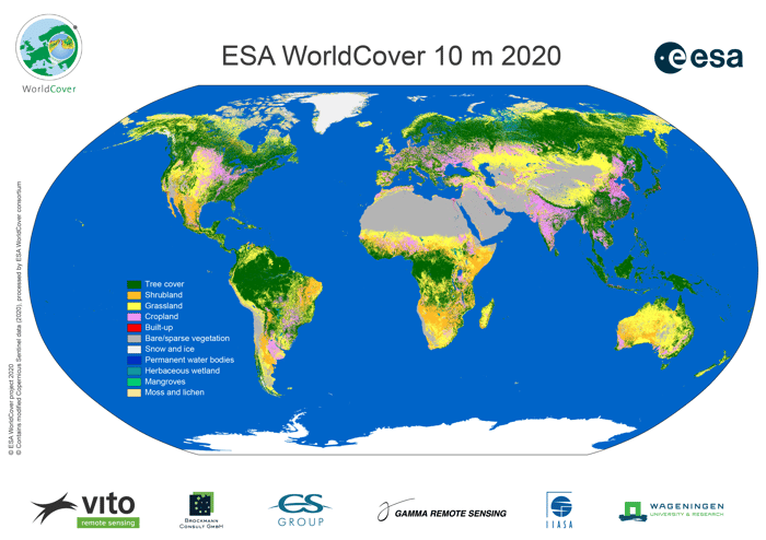
A new baseline global land cover product
The WorldCover map contains 11 different land cover classes at 10 m resolution. From cropland or grassland to permanent water bodies over built up areas and much more. The WorldCover map is valuable for a diverse set of users active in e.g. agriculture, biodiversity & nature conservation, land use planning, natural capital accounting, as well as climate change. Compared to the prototype presented last year, we even added an additional mangrove class at the request of several end users who wanted to see mangroves added because of the importance of this class as a carbon sink.
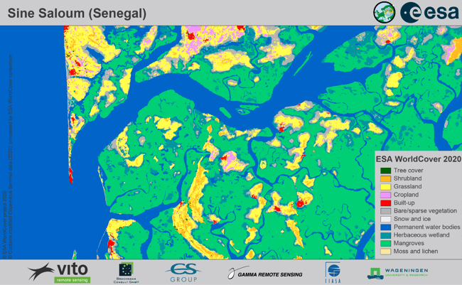
A detailed zoom on the Sine Saloum River Delta in Senegal dominated by mangroves
One of the key benefits of the WorldCover map is its unprecedented detail. By using both Sentinel-1 and Sentinel-2 satellite data we could not only enhance spatial resolution but it allows us also to provide land cover information in areas with persistent cloudcover and update the land cover map almost in real time. Providing much more spatial detail is crucial to ensure the map will meet our users’ requirements even better.
When zooming in on an urban area for example, we can clearly see the effect of the improved spatial resolution from 100 m to 10 m. Major roads and urban green areas are now also recognizable while before they were either discarded or lumped into the built-up class.
A detailed zoom on San Francisco: on the left WorldCover (10 m), on the right Copernicus Global Land 1(00 m) clearly showing the difference in spatial resolution.
Processing Petabytes of data in less than 5 days
As you can imagine, one of the main challenges of the ESA WorldCover project was the amount of data to process. Thanks to the very efficient processing pipeline and scalable infrastructure, we were able to process the whole world in less than 5 days.
Let me give you some more technical details on the product generation and characteristics:
- We used a total of 2 160 210 Sentinel-2 L2A products as input (all observations for 2020 with a cloudcover <90%)
- 291 855 Sentinel-1 GRD products were terrain corrected to Gamma0 and geocoded to the Sentinel-2 UTM grid using the Copernicus DEM. An additional multi-temporal speckle filter was also implemented.
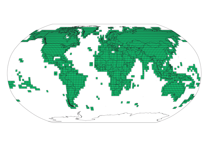
- The WorldCover products are provided per 3 x 3 degree tile (see figure below) as Cloud Optimized GeoTIFFs (COGs)
- Quality indicators for the input data are provided together with the Map layer with 11 classes
- The total size of the product is about 115 GB (excluding the Quality indicator)
 One of the key requirements of the ESA WorldCover project was to have it independently validated following the requirements of the Committee on Earth Observation Satellites (CEOS) Working Group on Calibration and Validation (WGCV) Land Product Validation (LPV). This validation, carried out by Wageningen University, showed that the overall accuracy of the WorldCover product with 11 classes is 74.4% on a global scale, with accuracy levels by continent ranging from 68 to 81%. More details on this validation can be found in the product validation report available on the WorldCover website.
Free and open access via the online viewer
One of the major assets of the WorldCover map is that it’s accessible open and free for anyone interested in monitoring global land cover changes. To provide a user-friendly access the WorldCover map is released in a brand new online viewer.
The WorldCover viewer displays the WorldCover map globally and also allows for comparison of area statistics between countries and regions. Moreover, it offers the possibility to give feedback on the product and to download it in standard geographic projection (EPSG:4326).

Next to our dedicated WorldCover viewer, the new global land cover map is also published as part of the Google Earth Engine (GEE) Data Catalog. Users familiar with the GEE platform can use this to perform customized analyses and visualizations. We also developed an Earth Engine app based on this asset.
The WorldCover map is released on October 20, 2021 during the ESA WorldCover webinar. Click here to view the webinar recording or share it with your network. More information about the WorldCover map including how to download and use the WorldCover product, the validation report, etc., can also be found on the WorldCover website
-----------------------
The WorldCover consortium consists of a group of highly experienced European service providers and research organizations, covering all relevant aspects of land cover mapping. VITO (Belgium) is the prime contractor of the WorldCover consortium together with Brockmann Consult (Germany), CS SI (France), Gamma Remote Sensing AG (Switzerland), International Institute for Applied Systems Analysis (Austria) and Wageningen University (The Netherlands). They have a long track record of collaboration in diverse European and ESA projects, as well as the Copernicus Land and Climate Change Services.


/lewis-latham-0huRqQjz81A-unsplash.jpg)
/boudewijn-huysmans-_iyh6g5KHQA-unsplash.jpg)
/Land%20use%20model%20+%20green%20city.png)