
Simplifying Earth observation data access and processing
Earth Observation (EO) data plays a crucial role in environmental monitoring, supporting scientific research, and enabling informed decision-making. However, accessing and processing large amount of datasets can be quite challenging. Users often need to navigate to multiple sources, download large files, and adopt various processing methods. These steps are barriers that limit the full potential of EO data.
To address these challenges, the Copernicus Data Space Ecosystem (CDSE) was introduced as a centralised hub that provides free, harmonised access to a wide range of EO products. These include Sentinel satellite data, Digital Elevation Models (DEMs), mosaics, value-added services such as biophysical parameters like FAPAR (Fraction of Absorbed Photosynthetically Active Radiation) and many other products. Beyond data access, CDSE also offers multiple cloud-native tools and APIs to simplify the EO workflows. One of the key services within this ecosystem is the openEO API, which provides a unified interface for everything from data discovery and preprocessing to large-scale analysis and deep learning.
Bridging users and EO workflows to deliver high-impact EO services
openEO is an open-source API that provides standardised access to EO data and simplifies the deployment of processing workflows as scalable, cost-efficient services. By eliminating infrastructure-related complexities, it empowers researchers, developers, and organisations to focus on deriving meaningful insights. It bridges the gap between users and cloud-based infrastructure, enabling developers, researchers, and data scientists to tackle complex geospatial challenges through a unified interface and distributed computing environments.
As an ever-evolving open-source tool, openEO continuously expands its capabilities to improve accessibility, interoperability, and scalability of EO workflows. Recent developments in openEO provide powerful and flexible solutions for managing and scaling complex EO processing tasks such as:
- Access multiple EO datasets:
openEO Federation allows users to access EO data from multiple providers through a unified interface. - External data integration:
openEO API enables users to load externally hosted datasets as a static SpatioTemporal Asset Catalogue (STAC) or an STAC API Collection. This ensures a broader data availability beyond the participating backends. - Advance functionalities:
With the recent advancements, openEO supports large-scale processing, integration of foundation models, machine learning techniques and reusability of algorithms across workflows.
These openEO capabilities are already validated in several large-scale operational projects such as ESA WorldCereal , Copernicus Global Land Cover, Tropical Forestry Mapping and Monitoring Service (LCFM), World Ecosystem Extent Dynamics (WEED), GrasslandWatch and many more. These initiatives leverage openEO’s robust, scalable, and interoperable framework to deliver high-impact Earth observation services.
At ESA Living Planet Symposium 2025 (LPS25), users are invited to explore how openEO enables operational geospatial solutions across diverse EO pipelines. Several of these projects will be featured during the symposium, offering deeper insights into their implementation using openEO: ESA WorldCereal in F.02.07, LCFM in D.02.03, WEED in F.04.08, and GrasslandWatch during A.02.07). Let me give you two specific use cases that showcase openEO’s flexibility.
ESA WorldCereal and openEO: Advancing global agriculture through scalable EO workflows
Launched in 2020, ESA WorldCereal has built the first open-access system capable of delivering global-scale agricultural insights at an unprecedented 10-meter resolution. This initiative empowers researchers, policymakers, and farmers to monitor crop production, assess food security risks, and support sustainable agriculture.
Within CDSE, openEO enhances WorldCereal's implementation by providing direct access to multiple data sources and fostering interoperability across EO datasets, tools, and cloud services. Its flexibility enables users to work seamlessly with optical, SAR, and meteorological data, facilitating data assimilation and multi-observation. Furthermore, the system's generic design extends beyond agriculture, making it potentially applicable to other applications requiring pixel level classification based on EO time series.

WorldCereal 2021 temporary crop extent map, resampled to ~0.004 ° resolution. Each pixel contains a number between 0 and 100, indicating the fractional cover of temporary crops within that pixel.
Read more about WorldCereal and how openEO streamlines and scales WorldCereal’s agricultural monitoring workflows through cloud-based processing and seamless EO service integration in this CDSE use case ‘Using openEO to streamline global crop mapping’.
Copernicus High-Resolution Layer on Croplands
The HRL Cropland product offers a comprehensive view of agricultural land use across Europe. It consists of several status layers that provide information not only on what is grown, but also how and when it is cultivated. Together, these layers help track farming practices, support policy implementation, and improve our understanding of cropland dynamics over time.
The HRL crop type product is generated through an advanced, scalable workflow designed to deliver detailed and reliable agricultural crop type information across Europe. At its core is a state-of-the-art, transformer-based machine learning model capable of generalizing across diverse landscapes and multiple years. Integrated into the openEO framework, it ensures scalability and broad accessibility. Kasper Bonte explains more about the full suite of HRL cropland products in the blog post ‘New Copernicus High-Resolution Layer on Croplands Launched for Europe’.

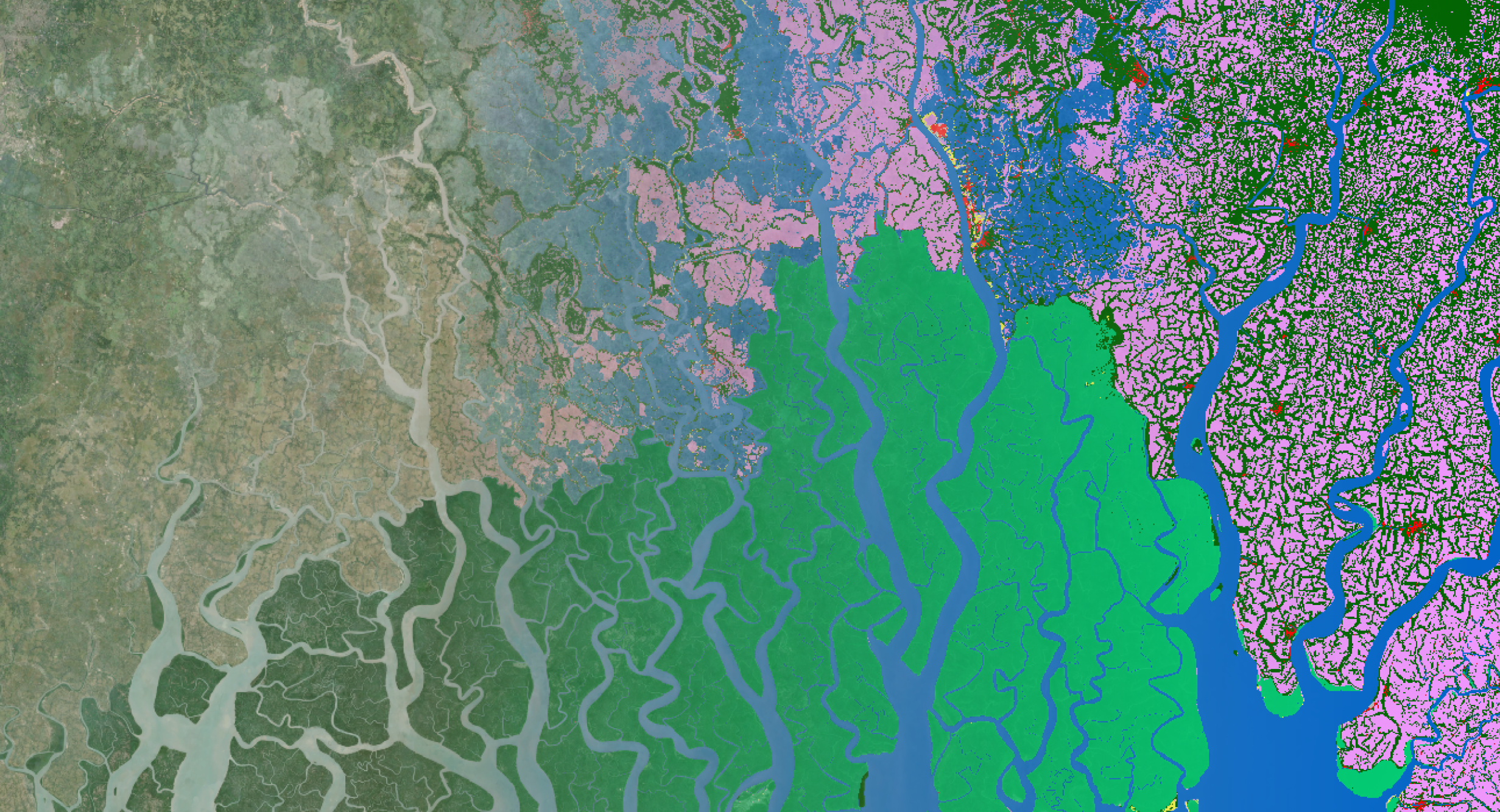
Zoom into crop type product for a region in France for period 2017-2021
Discover the power of openEO to support your workflows at ESA LPS25
Are you wondering how to manage large volumes of datasets from different sources? Do you want to make your workflow scalable? Or are you looking to join a truly FAIR and open ecosystem, free from commercial conflicts of interest?
Contact us to see how openEO can support you in developing scalable and flexible EO workflows or join us at the ESA Living Planet Symposium 2025. You can meet the openEO team throughout the entire conference during different hands-on sessions, presentations, demonstrations, tutorials and at the exhibition on the CDSE, ESA (EOF), Open Science in Making session and VITO Remote Sensing booths. Our openEO experts will be available for direct interaction, on-request demos and open to discussion for possible collaboration.
Here's an overview of a few sessions in which you can discover more about openEO’s capabilities.
-
TUTORIAL: Server-Side Processing:
With openEO, users can develop scalable and reusable workflows directly on federated cloud backends, eliminating the need to download large datasets locally. This approach not only speeds up processing but also supports user to focus more on the use case rather than requiring advanced knowledge on high-performance computing (HPC). Join Pratichhya Sharma and Victor Verhaert during the D.03.13 tutorial session, where they walk you through a simple use case in CDSE. With openEO, users can develop scalable and reusable workflows directly on federated cloud backends, eliminating the need to download large datasets locally. This approach not only speeds up processing but also supports user to focus more on the use case rather than requiring advanced knowledge on high-performance computing (HPC). Join Pratichhya Sharma and Victor Verhaert during the D.03.13 tutorial session, where they walk you through a simple use case in CDSE.
- Sunday 22/06/2025 – 15:30
- Code Once, Reuse and Scale Seamlessly: Build EO Workflows using openEO in the Copernicus Data Space Ecosystem
- Room 1.85/1.86
- Presenter: Pratichhya Sharma and Victor Verhaert
-
ORAL PRESENTATON: Simplify Deployment
The openEO community maintains a set of Open Source Software components ranging from client libraries to full backend solutions that allow you to process EO data at scale in the cloud or on High Performance Computing. Join Jeroen Dries in session D.03.02 to learn more straight form the development team about the Geotrellis backend deployed in CDSE.
- Monday 23/06/2025 – 14:00
- Deploying your own openEO: the Geotrellis backend
- Hall N1/N2
- Presenter: Jeroen Dries
-
DEMONSTRATION: Fair & Transparent
openEO aims to support FAIR principles and open-science community. These principles are seamlessly integrated into the Copernicus Data Space Ecosystem (CDSE), making it intuitive to adhere to them. Feel free to join Victor Verhaert during the D.02.26 session to discover more about "A.I. in F.A.I.R.".
- Tuesday 24/06/2025 – 14:37
- Putting the A.I. in F.A.I.R.: Unlocking Reproducible Machine Learning through openEO
- EO Arena – ESA booth
- Presenter: Victor Verhaert
-
ORAL PRESENTATION: One API to Rule Them All
openEO acts as a unified solution to a long-standing challenge in Earth Observation: multiple data providers, downloading large volumes of data, and analysing and managing them. By providing a single, standardized API, openEO connects users to a wide range of data and research infrastructures, without the need to juggle multiple accounts or adapt to different interfaces. Join us during the CDSE User Review Meeting (session D.05.05) to learn more about openEO.
- Tuesday 24/06/2025 – 15:15
- Low-Cost, High-Impact: Advanced Copernicus Data Analysis with openEO on the Cloud
- Hall N1/N2
- Presenter: Jeroen Dries
-
POSTER PRESENTATION: Unlock Scalable AI for EO
The integration of Machine Learning (ML) and Deep Learning (DL) in Remote Sensing has revolutionised the way a vast amount of Earth Observation (EO) data is processed and analysed. To make ML more accessible for EO practitioners, openEO integrates key algorithms such as Random Forest and supports integration of foundational models. Hans Vanrompay and Victor Verhaert will explain more D.04.05 session, highlighting the scalability of openEO workflows.
- Thursday 26/06/2025 – 17:45
- Scaling Earth Observation Workflows with openEO: Managing Large-Scale Processing Efficiently
- X5-Poster Area
- Presenters: Hans Vanrompay and Victor Verhaert
-
POSTER PRESENTATION: Customise with UDFs:
In the Earth Observation (EO) domain, data analysis ranges from simple image processing tasks like band-math to complex workflows. While openEO provides numerous features and functions for data analysis, given the large scope of the field, not all features might be available. To address this, openEO supports User-Defined Functions (UDFs). These UDFs are implemented as standard Python scripts using libraries such as Xarray or Numpy. They allow users to implement custom workflows tailored to specific research requirements. Parallel to the poster on scalability is the D.04.03 session. Here, Hans and Victor will showcase how this feature of openEO is validated in different projects using openEO.
- Thursday 26/06/2025 – 17:45
- Unlocking ML and Foundation Models within openEO
- X5-Poster Area
- Presenters: Hans Vanrompay and Victor Verhaert
Discover more openEO-related contributions that will be given during ESA LPS25 at https://dataspace.copernicus.eu/events/esa-living-planet-symposium-2025 or https://remotesensing.vito.be/news/meet-us-esa-living-planet-symposium-2025.
In addition to the presentations given by the openEO team, there are of course several other presentations from users and projects that will showcase how openEO is integrated into their workflows. Looking forward to showing you the wide variety of capabilities during one of the world’s premier events on Earth observation.

/lewis-latham-0huRqQjz81A-unsplash.jpg)