Improved spatial detail and continuous annual updates
Launched in 2024 under the Copernicus Land Monitoring Service (CLMS), the Copernicus Land Cover and Tropical Forest Mapping and Monitoring (LCFM) service delivers a new suite of global land cover and pan-tropical forest monitoring products at 10 m resolution, updated annually to capture environmental change with unprecedented detail. After developing multiple data products for the 100 m Copernicus Global Land Cover, ESA WorldCover, and the REDDCopernicus projects, the LCFM service represents a major leap forward in both resolution and consistency. Its fine spatial detail of 10 m resolution enables precise plot-level monitoring on a global scale, while annual updates will ensure continuous tracking of global land cover and forest change.
In addition, the LCFM service will also resume the Copernicus Land Cover time series, providing new yearly updates from 2020 through 2026, and will introduce innovative sub-annual land cover products, capturing seasonal variations and enabling near real-time tracking of extreme events or land conversion. Together, these datasets form a consistent, long-term foundation for monitoring land use and deforestation worldwide
First products available via the CDSE
The LCFM service released its first products in June 2025 with the global Land Cover Map at 10 m (LCM-10) and the pan-tropical Tree Cover Density Map (TCD-10) for the year 2020. These products are open to all and freely available through the Copernicus Data Space Ecosystem (CDSE). Annual maps for 2021-2026 will follow, building a complete and consistent time series for global monitoring. Together, these products establish a robust and innovative baseline for global land cover mapping within the Copernicus Land Monitoring Service and available via CDSE.

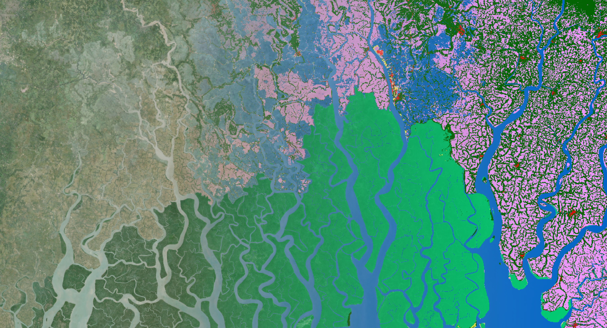
The LCFM 10 m Global Land Cover Map (LCM-10) released in June 2025
© European Union's Copernicus Land Monitoring Service information; DOI.
- The Global Land Cover Map (LCM-10): The LCM-10 product delivers an annual global land cover map at 10 m resolution, comprising 11 thematic classes that represent major vegetation types, bare surfaces, built-up areas, permanent water bodies, and snow or ice. Updated each year, it supports a wide range of applications, including monitoring deforestation, assessing biodiversity change, and analyzing urban expansion and agricultural dynamics.
- The Pan-Tropical Tree Cover Density Map (TCD-10): The TCD-10 product provides information about tree cover density across the pan-tropical regions at 10 m resolution, offering a detailed view of canopy closure. Values are grouped into 10 classes, each representing a 10% range of tree cover density. Unlike categorical land cover maps, TCD-10 provides a quantitative measure of forest structure and quality. This makes it possible to track not just where forests are, but also how dense and resilient they are. Such insights are crucial for assessing carbon storage, biodiversity, and ecosystem health, and they directly support compliance with environmental frameworks such as the EU Deforestation Regulation (EUDR).

The LCFM 10 m Pan-Tropical Tree Cover Density Map (TCD-10) released in June 2025
© European Union's Copernicus Land Monitoring Service information; DOI.
The LCFM products are fully integrated into the Copernicus Data Space Ecosystem (CDSE) and can be accessed via the:
- Copernicus Browser: Access LCM-10 and TCD-10 to visualize, analyze, and download.
- S3 access for direct retrieval from the EODATA S3 bucket.
- OData API for programmatic queries and integration into workflows.
More details can be found on the CDSE documentation. Technical details and usage guidelines for the Copernicus LCFM products are provided in the LCM-10 and the TCD-10 Product User Manuals.
Global Land Cover Applications
The 10 m Copernicus LCFM products enable long-term tracking of deforestation, biodiversity loss, and climate impacts. When forests disappear, soil degrades, carbon is released, and ecosystems decline. Covering everything from crop fields and urban areas to coastlines and tropical forests, the LCFM products reveal environmental change with unprecedented detail. Let me share some land cover application examples:
- Tree cover loss in the Gran Chaco
- Sundarbans mangroves: carbon sinks under pressure
- Urban expansion and tree cover in cities
- Cropland extent monitoring


Methods and Innovations
From a technical perspective, the LCM-10 product implements three key innovations: A new global training dataset, improved pre-processing pipeline and the EvoNet deep learning algorithm. These advances increase accuracy, reduce artefacts, and deliver better classification of land cover classes in complex and heterogeneous landscapes.
A new global training dataset designed for deep learning
Evotrain, was created and designed from the start to be deep learning ready. Its sampling strategy was tailored to capture a spatially balanced and land cover stratified set of locations, ensuring that both common and rare classes are represented across diverse environments. It contains 54,000 locations that were annotated with annual land cover labels by experts using Geo-Wiki Evolution, a tool developed specifically for this task with AI assistance to streamline the process. In future, as part of LCFM, the Evotrain dataset and the LCM-TD expert annotations will be released publicly.

Geo-Wiki Evolution interface showing an expert annotation collected in Emilia-Romagna, Italy
Enhanced Pre-processing of Sentinel-2
A redesigned pre-processing pipeline for Sentinel-2 time series was implemented to address residual clouds in the Sentinel-2 products. An innovative cloud detection algorithm was developed that provides continuous indicators of clouds, cloud shadows, and snow occlusion. These indicators are used in a new compositing and reconstruction algorithm, which blends observations according to their quality. The result is cleaner time series with less noise and fewer artefacts, yielding more stable input features and ultimately more accurate land cover maps.

Example of Sentinel-2 L2A median RGB features over Colombia for a) ESA WorldCover V200, b) LCFM LCM-10 V100, highlighting the improvement in removal of residual clouds artefacts.
EvoNet
At the core of LCM-10 is EvoNet, a new deep learning algorithm developed for global land cover mapping. EvoNet was designed to merge the strengths of convolutional neural networks (CNNs), which learn spatial context, with pixel-level classifiers that preserve fine details.
Its architecture combines two components: a modified U-Net that extracts spatial features, and a multi-layer perceptron (MLP) that classifies each pixel while leveraging the contextual information provided by the CNN. This design enables the model to capture both fine local detail (e.g. roads) and broader landscape patterns (e.g. cropland).
Compared to pixel-only methods, EvoNet is more robust, less prone to overfitting to noise, and generalizes better across diverse regions. It also retains higher spatial detail than conventional CNNs commonly used for land cover classification.
Comparison of LCFM LCM-10 (left) and ESA WorldCover 2021 (right) over Cali, Colombia, highlighting clearer separation between cropland and tree cover, improved built-up detection, and more accurate mapping of roads. View in the CDSE Copernicus Browser.
Outlook and upcoming products
At this moment the LCFM service is developing the annual LCM-10 products for 2021-2025 together with the corresponding land cover change products (LCCM-10). These products will be gradually released during 2026.
In parallel, the service will also start delivering monthly Land Surface Categories (LSC). These are sub-annual land cover maps with a reduced legend, leaving out temporally defined classes such as cropland and herbaceous wetlands. Produced every month, they will enable new applications in monitoring seasonal dynamics and detecting rapid land surface changes.
These annual and monthly products will expand the LCFM product suite into a powerful catalogue for continuous global monitoring of environmental change.

The Copernicus Land Cover and Tropical Forest Mapping and Monitoring (LCFM) service operates under the authority of the European Commission’s Joint Research Centre (JRC) and is implemented by a consortium of European service providers and research organizations, recognized globally for their expertise in land monitoring and Earth observation. The LCFM consortium is led by VITO Remote Sensing with partners GAF, GeoVille, GFZ, IGN FI, IIASA along with support from two sub-contractors, i.e., Sinergise and Telespazio Ibérica.

/lewis-latham-0huRqQjz81A-unsplash.jpg)