Intelligence data for local and regional administrations
Policy makers, planners or law enforcers at a local administrative level rely on very high-resolution airborne imagery, airborne LiDAR or mobile mapping as their standard remote sensing intelligence data. The application domains are very diverse: agriculture, civil infrastructure, mobility, circular economy, energy, ecology, …
In Flanders for example, Digitaal Vlaanderen organizes the acquisition of an area-wide orthophoto at 20 cm resolution on a yearly basis, and once every decade an area-wide LiDAR dataset at 20 points per square meter is acquired.
For critical infrastructure (coast, waterways, …) the data acquisition is performed more locally and frequently, but for the vast majority of the land area, the update frequency is not more than once every year. These datasets support 3D applications and all kind of mapping, segmentation and object recognition applications, but there is one dimension lagging behind: TIME. To quickly assess and respond to things happening in our highly dynamic socio-economic environment, more frequent intelligence data is needed.
The need for resolution
Resolution is key for the adoption of remote sensing in the operational workflows of public administrations and other businesses. We can all live with a certain degree of uncertainty, but if we cannot unambiguously detect what we are looking at, remote sensing data will not be adopted in operational application workflows. For many decades airborne remote sensing was and still is the default intelligence information source because of the supreme data quality for visual or computer aided vision tasks.
But in the last years the EO data landscape evolved tremendously with the emergence of the Copernicus Sentinel-1 and Sentinel-2 satellites. S1 and S2 have been delivering useful data since around 2016 and already guarantee data continuity beyond 2030. With a spatial resolution of 10 meters, it is possible to detect changes within the administrative parcels. This spatial resolution itself may not be so impressive for detection or mapping tasks, but the ability to access a new Sentinel-1 as well as a new Sentinel-2 image for Flanders every 1-3 days is extremely interesting. This time-resolution enables new opportunities to timely detect the changes and support operational land and infrastructure management decisions.
Providing analysis ready data
All the raw Sentinel satellite images, speckled with noise and data gaps, are first pre-processed in the Terrascope platform. To support the user-segments active in planning, assessments and monitoring, Terrascope offers a time series web service ‘CropSAR’. CropSAR allows you to access the complete time-series of Sentinel-1 and Sentinel-2 derived parameters for a given area (e.g. an administrative parcel or a set of parcels) by 1 simple web service request. You no longer need to download series of images, Terrascope does all the image processing for you, so that you can focus on your specific use case.
Currently, we already see a new data fusion strategy emerging: airborne campaigns for a yearly crystal-clear visual overview (spatial resolution), the Sentinel missions for continuous monitoring of the dynamics in a region of interest (temporal resolution) in combination with existing (GIS)data.
The CropSAR service in combination with high resolution images and (field) data provides timely parcel change-detection notifications needed by the governmental agencies to support their task in monitoring the European Green Deal objectives.
Jo Van Valckenborgh - Programme Manager EODaS, Digitaal Vlaanderen
Towards operational applications
Within Flanders, Digitaal Vlaanderen is organizing the remote sensing data acquisitions that deliver the necessary intelligence data for the different administrations. They currently host the open data backends geopunt.be and download.vlaanderen.be to disseminate state-of-the art remote sensing and GIS data layers to administrations, businesses, and civilians.
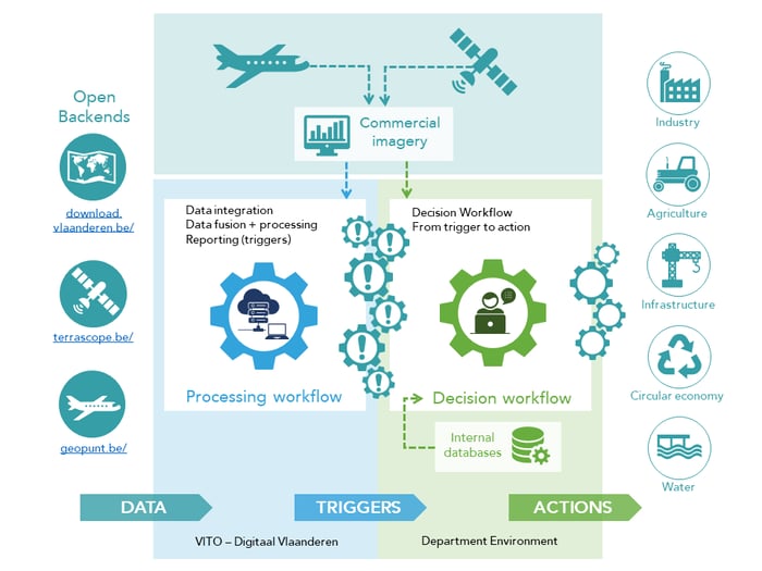
Since the release of the CropSAR service, we saw the emergence of a series of “proof of concept” (PoC) projects in different application areas to evaluate how these new and improved time series could be integrated in the operational workflows of public administrations. In all these PoC project we use a similar workflow: together with Digitaal Vlaanderen we first create a processing workflow that fuses information of GIS layers, airborne imagery and Sentinel time series able to detect changes relevant for the specific use case. In a second step, this approach gives the possibility to deliver the respective administrations “change notifications” as a trigger to cross check with their other in-house databases and decide if the change notification requires a response action in the field.

Digitaal Vlaanderen - VITO cooperation to integrate Terrascope services in the intelligence workflows of the regional and local administrations
Governance related next steps
From the first series of PoC projects, a few governance related issues became apparent:
- Structural integration of Terrascope’s CropSAR service:
Bringing all PoC projects with their respective application domain together would give us a combined advantage to monitor all administrative parcels in the Flemish region (about 5 million polygons). Area wide administrative parcel monitoring should thus be considered as a to be elaborated intelligence service. - Further development of a new and improved on-demand acquisition strategy:
In addition to the availability and increasing value the Sentinel missions for change detection, the availability of additional on-demand high resolution satellite/airborne data products remains important. The elaboration of a new structural system of on-demand acquisition of high spatial resolution remote sensing data is a clear next step. - Strengthening cross-administration cooperation:
We notice a clear need for a further strengthened and renewed cross-administration cooperation with respect to remote sensing applications. And in many of these applications, if not all, with a strong association of the application sector organizations.

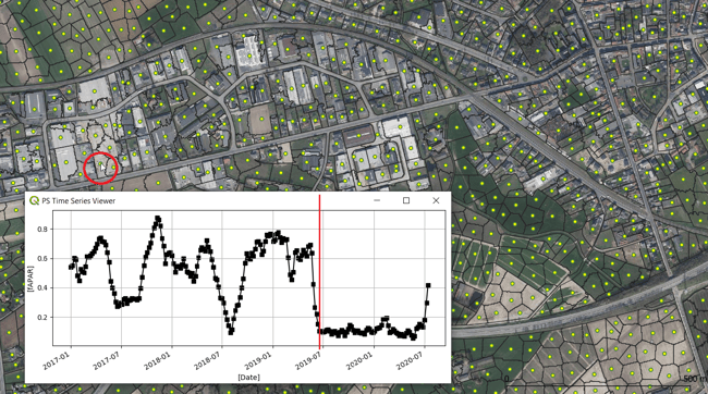
Administrative parcel-segment monitoring in QGIS: combining spatial high-res airborne imagery with temporal high-res fused Sentinel-1 and Sentinel-2 data.


/lewis-latham-0huRqQjz81A-unsplash.jpg)
/boudewijn-huysmans-_iyh6g5KHQA-unsplash.jpg)
/Land%20use%20model%20+%20green%20city.png)