/boudewijn-huysmans-_iyh6g5KHQA-unsplash.jpg)
SEN4LDN: Advancing High-Resolution Land Degradation Neutrality Monitoring
Efficient monitoring of land degradation (LD) requires constant monitoring of various biophysical and biochemical characteristics of the land. These disturbances can range from rapid land cover change (e.g. fire, logging, or urban expansion) to continuous and slower degradation of soil and land quality (due to e.g. inadequate land management or soil erosion). Monitoring LD at large scales is only possible with the help of satellite Earth observation (EO) data. However, existing global and national monitoring efforts have largely relied on coarse-resolution EO datasets (typically 300 m or greater), limiting their ability to detect finer-scale land changes and provide actionable insights at the local level. To address these limitations, the ESA-funded Sentinels for Land Degradation Neutrality Monitoring (SEN4LDN) project aimed to develop an automated EO-based approach for mapping land degradation and restoration using high-resolution Sentinel-2 data. The effectiveness of the developed approach was demonstrated through three early adopter case studies characterised by diverse land use practices and geographical settings.
Key Innovations
Indicator SDG 15.3.1 is measured in terms of three sub-indicators:
- land cover and land cover change,
- the status and change in land productivity,
- and change in carbon stocks above and below ground, with soil organic carbon (SOC) stock as the initial metric.
Trends in Land Cover
Within SEN4LDN we have developed an automated global land cover change algorithm to generate discrete and continuous land cover degradation products at an impressive 10-meter resolution. The algorithm ensures consistent land cover time series, incorporating advanced pre-processing techniques such as improved cloud detection, interpolation, and temporal compositing. Deep learning features and pixel classifiers enhance spatial accuracy, while change detection and post-processing stabilize class fluctuations. Beyond the improved spatial and temporal resolution, a key innovation of this approach is that both discrete (LCD) and continuous land cover degradation probabilities (LCD-PROB) are derived, offering a more nuanced understanding of land cover dynamics.
/SEN4LDN%20Fig1%20land%20degradation.png?width=3772&height=2169&name=SEN4LDN%20Fig1%20land%20degradation.png) Land degradation due to deforestation in a ~10 km x 10 km use case area around 39.2°N, 8.9°W (Aveiras de Cima, Portugal)
Land degradation due to deforestation in a ~10 km x 10 km use case area around 39.2°N, 8.9°W (Aveiras de Cima, Portugal)
Trends in Land Productivity
Using TIMESAT processing on Sentinel-2 derived vegetation indices, SEN4LDN generates land productivity degradation classes and continuous values at a resolution of 10 meters. Seasonal Total Productivity (TPROD) trends are analysed using robust statistical methods. Productivity performance is categorized into degrading, stable, or improving classes, with spatial filters applied to refine outputs. The Land Productivity Degradation (LPD) indicator and continuous LPD-INDEX integrate trend and performance data, providing actionable insights into land productivity changes.
/SEN4LDN%20Fig2%20land%20degradation.png?width=3954&height=2367&name=SEN4LDN%20Fig2%20land%20degradation.png) Land degradation due to a negative trend in land productivity in a ~40 km x 40 km use case area around 2.8°N, 34.3°E (Karamoja region, Uganda)
Land degradation due to a negative trend in land productivity in a ~40 km x 40 km use case area around 2.8°N, 34.3°E (Karamoja region, Uganda)
Trends in Carbon Stocks
The project explores above-ground biomass (AGB) mapping through hybrid approaches, combining gain-loss flux models and stock change methodologies. While the spatial resolution is lower (100 meters) compared to the other sub-indicators, SEN4LDN highlights the need for high-resolution global trend data on soil organic carbon (SOC) to assess total carbon stocks comprehensively. Future research aims to integrate SOC and AGB methodologies for improved carbon stock estimation.
/SEN4LDN%20Fig3%20land%20degradation.png?width=1222&height=688&name=SEN4LDN%20Fig3%20land%20degradation.png) Example of hybrid AGB change mapping method 2010-2018, Portugal case study.
Example of hybrid AGB change mapping method 2010-2018, Portugal case study.
Integration for SDG 15.3.1
SEN4LDN contributes to the Sustainable Development Goal (SDG) 15.3.1 indicator on LDN, which measures the proportion of degraded land over total land area. The project tests the "One-Out-All-Out" (1OAO) approach and explores continuous sub-indicator aggregation using LCD-PROB and LPD index to generate land degradation probabilities (LD-INDEX).
/SEN4LDN%20Fig4%20land%20degradation.png?width=3759&height=1907&name=SEN4LDN%20Fig4%20land%20degradation.png) Land degradation due to mining expansion in a ~20 km x 20 km use case area around 9.7°N, 73.5°W (Corredor minero del Cesar, Colombia)
Land degradation due to mining expansion in a ~20 km x 20 km use case area around 9.7°N, 73.5°W (Corredor minero del Cesar, Colombia)
National Demonstration Products: Strengths and Limitations
SEN4LDN delivers an EO-based methodology for national land degradation assessments at high temporal frequency (annual) and spatial resolution (10 m). National demonstrations and use cases in Portugal, Uganda, and Colombia showcase its practical applications, while early adopters were engaged through living lab workshops to refine the approach.
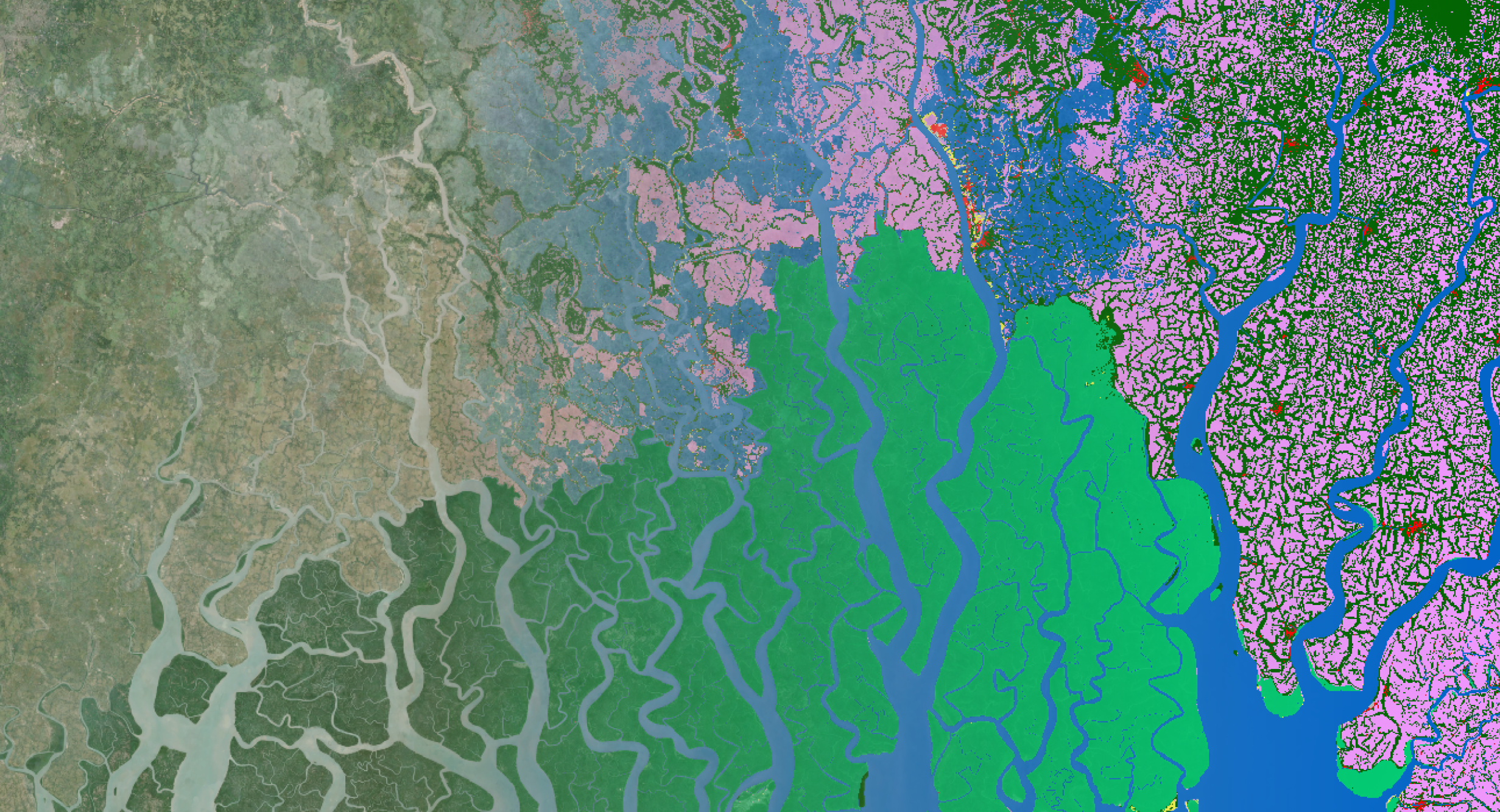
/SEN4LDN%20Fig5%20land%20degradation.png?width=3900&height=1472&name=SEN4LDN%20Fig5%20land%20degradation.png) LD-index map for the three national demonstrations (Uganda, Portugal, and Colombia). The LD-index is based on a continuous sub-indicator integration method that combines the continuous land cover degradation and land productivity degradation products.
LD-index map for the three national demonstrations (Uganda, Portugal, and Colombia). The LD-index is based on a continuous sub-indicator integration method that combines the continuous land cover degradation and land productivity degradation products.
An important limitation of the evolution towards high spatial resolution by using Sentinel-2 10 m input products – available since 2017 – is the lack of a historical archive to respond to UNCCD methodology demands. Going backwards in time with other sensors is difficult, because the inconsistency in the frequency of observations can result in temporal inconsistencies. More research is needed to look at ways to bypass these constraints.
There are also region-specific processes that are hard to monitor with a global applicable methodology and resulting datasets. In this respect, algorithms could be deepened to reach specific thematic detail based on adaptable schemes at country scale, starting from the global dataset. This could be done by integration of national data, such as local training data or detailed maps, in the process.
A great achievement of SEN4LDN is the high interannual consistency of the annual land cover maps. In addition, the continuous scale in the annual output products allows us to evaluate land cover transition probabilities. Nevertheless, disaggregation into more narrow land cover classes is required to respond to region-specific needs, which is becoming more feasible with the evolution towards high spatial resolution, but further research is required. Another limitation, both for land cover mapping and land productivity evaluation, is related to the lack of good satellite observations over areas with persistent cloud cover. This problem could be tackled through the incorporation of Sentinel-1 (synthetic aperture radar) data in the workflow.
Key Outcomes and Impact
The SEN4LDN project focused on developing an EO method for the national assessment of land degradation and improvement at high temporal frequency (annual) and high spatial resolution (10 m) that is applicable at global scale. Validated through ground sampling and consistency evaluation, the project provides automated algorithms for land cover and productivity monitoring, alongside exploratory methods for carbon stock evaluation.
In addition, SEN4LDN developed continuous sub-indicators and explored a continuous sub-indicator integration method that allows to provide (a proxy for) uncertainties in the identification of ongoing degradation or improvement processes. In this respect, SEN4LDN has provided tangible results to support the UNCCD and GEO-LDN in defining the next steps to increase the spatial and thematic detail of national assessments of land degradation and improvement.
The upcoming implementation into platforms like the Copernicus Data Space Ecosystem (CDSE) and openEO aims to enhance user uptake, ensuring the methodology's accessibility and scalability. SEN4LDN represents a significant step forward in leveraging EO technologies to address global land degradation challenges and support sustainable land management.
Join Us at Living Planet Symposium
Curious to learn more about land degradation and how it can support your work in agriculture, land monitoring, or policy? Visit the VITO booth at the Living Planet Symposium 2025 in Vienna during June 23-27. Our Remote Sensing experts are looking forward to answering your questions and showing how EO technologies can address global land degradation challenges and support sustainable land management.
Don't miss Carolien Toté's presentation on Tuesday, June 24 at 8:30 AM CET on High-Resolution Land Degradation Neutrality Monitoring to hear more about the achievements of the ESA SEN4LDN project (session F.04.03, room 1.61/1.62).
Let’s connect in Vienna and discuss land degradation neutrality! Cannot make it to Vienna? Feel free to contact us online.
/Living%20Planet%20Symposium%202025%20LPS25%20Themes.jpg?width=687&height=385&name=Living%20Planet%20Symposium%202025%20LPS25%20Themes.jpg)
/Blog_WorldCereal_1200x650.png)
/lewis-latham-0huRqQjz81A-unsplash.jpg)