A clear need for timely and accurate information to improve flood response!
While the devastating floods that occurred in Belgium and Germany in July 2021 are still in memory, we’ve witnessed many new floods, happening all over the world. Floods are the most common and most costly natural disasters in Europe. It is clear that such extreme weather events are occurring more often, and we have to better prepare ourselves for future floods. However, testimonies from stakeholders highlight the lack of timely and accurate information to organize the flood response when a disaster hits.
Therefore, BELSPO initiated the STEREO project FLOWS, FLOod crisis management With Earth observation Solutions. The goal is to optimize the use of Earth Observation (EO) technologies for flood response. Together with ISSeP (Belgium), Ghent University (Belgium), NGI (Belgium) and DLR (Germany), we aim to create valuable EO-based flood products, tailored to the operational needs of flood crisis managers, and combine them in integrated hot spot maps. Building on the experience and data acquired of the 2021 floods, we aspire to:
• Enhance situational awareness
• Streamline emergency response efforts
• Improve long-term planning
Combining data to create disaster hot spot maps
In times of crisis, rapid information is crucial! The strength but also the challenge lays in using information from diverse sources. The availability of data is not the issue, it’s how to use, combine and integrate the data to retrieve useful information on what actions are needed! Satellites cover large areas, but drones are very flexible. SAR imagery is weather-independent, but optical imagery is easier to interpret. These data all have different qualities, resolutions, uncertainties, and acquisition times.
By utilizing data harmonization and probabilistic fusion techniques, we aim to merge these diverse datasets to create comprehensive hot spot maps. Unlike comprehensive risk assessments, these hot spot maps are based on (real-time) observations during an ongoing disaster, offering an up-to-date situational overview that complements existing knowledge. These maps not only guide and prioritize disaster management activities, they can also indicate for which areas additional data acquisition is needed.
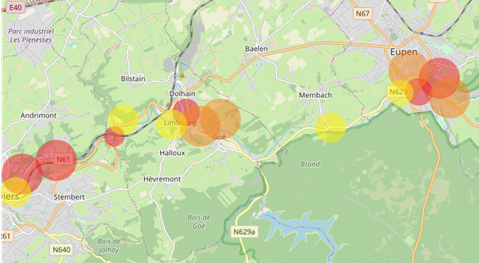
Conceptual example of the hot spot maps where different flood extent and impact products are integrated into a single, easy-to-interpret layer to have an up-to-date situational overview.
Fast and reliable flood maps
The hot spot maps are built upon flood extent maps, which are the foundation for flood response and impact analysis. To get the most accurate and complete situational overview possible, we combine different modalities and platforms. Satellite data from the Copernicus Sentinels are indispensable! Leveraging the Synthetic Aperture Radar (SAR) technology aboard Sentinel-1 and the multispectral sensor aboard Sentinel-2, these satellites provide invaluable data for capturing flood dynamics with high spatial and temporal resolution. Thanks to TerraFlood and Geo.Informed we already have workflows in place to delineate floods based on both Sentinel-1 and Sentinel-2.
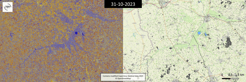
Evolution of the 2023 flood event along the Yser river in the northwest of Belgium, as captured by the Copernicus Sentinel-1 satellite. The maps are automatically produced using the TerraFlood algorithm.
Commercial SAR imagery provides sub-meter resolution and flexible tasking, which allows us to optimize the acquisitions to the timing of the disaster and stakeholder needs. On the other hand, these data typically contain more noise. By leveraging data from providers like Capella Space and TerraSAR-X, we will investigate the potential of these data, both for rural and urban floods, and develop dedicated flood delineation workflows.
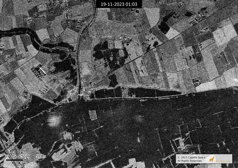
Comparison of Copernicus Sentinel-1 and Capella Space images of the village Fintele, acquired on 19 November 2023 at 06:59 and 01:02 (UTC) respectively, illustrating the significant difference in resolution.
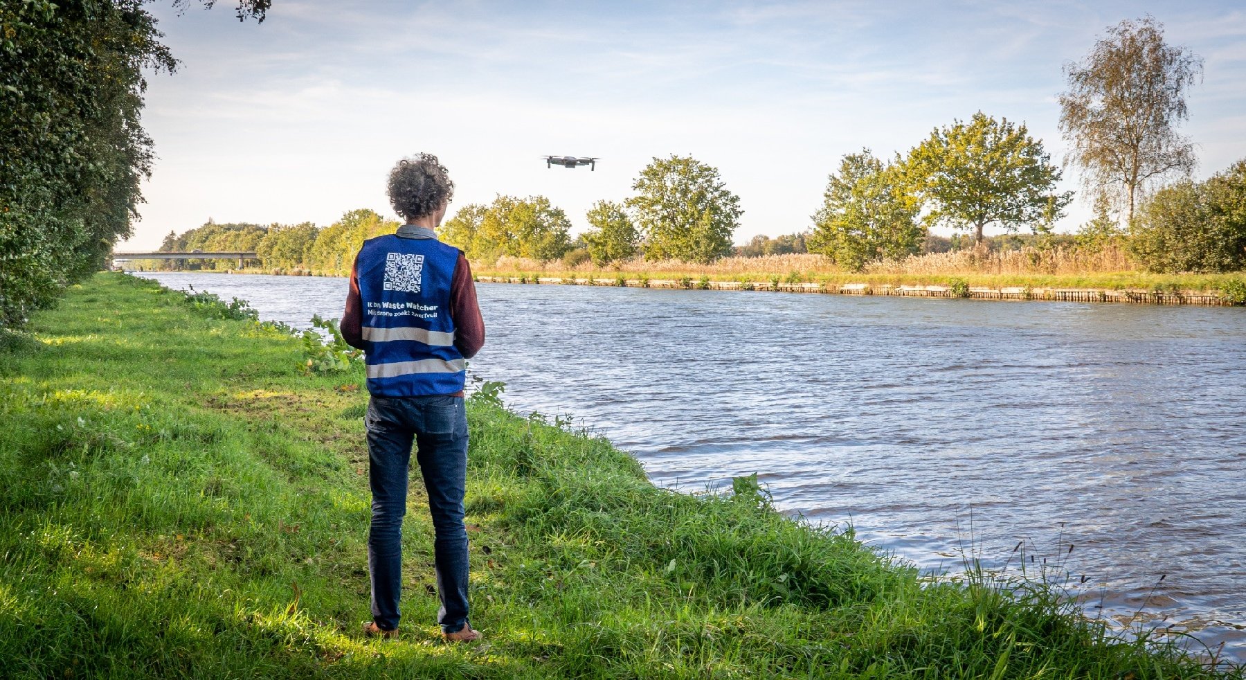
Unmanned Aerial Vehicles (UAVs) or drones offer unparalleled flexibility and agility compared to traditional satellite platforms. They are increasingly used during emergencies, but their usage mostly remains limited to visual interpretation whilst there is much more possible. We aim to further valorize these data by developing an automated flood mapping workflow specifically for drone data (natural color, RGB). To use drone images in operational map applications, we need orthogonal drone imagery. Now, drone images are often acquired from an oblique perspective, To unlock this oblique imagery, we are developing a photogrammetric workflow that can convert oblique images and videos into orthorectified layers that can be further analyzed. Depending on which metadata are available, this can be done in a fully or semi-automated way.

|
Demonstration of the photogrammetric orthorectification workflow. Left pane shows a video of the 2021 floods in Belgium, posted on Facebook by Quentin Van Belle. Right pane shows the corresponding orthorectified product, created in a semi-automated way.
During an emergency, every second counts and waiting for a drone flight to finish before analyzing the imagery can cost lives. Therefore, we are developing on-board analytics solutions that enable drones to autonomously detect flooded areas and potential victims in real time. By integrating computer vision algorithms and semantic prioritization techniques, flight paths can be optimized to prioritize areas of interest for detailed inspection.
Short and long-term impact assessment
Apart from supporting rapid flood response management, we also need to think about recovery and long-term planning. We need to assess the short- and long-term impacts of floods on various aspects such as population, infrastructure, and the environment. By leveraging aerial and satellite imagery, and integrating deep learning techniques, we can develop automated methods for damage assessment and classification.
To maximize the impact of our research, we engage with several key stakeholders including water and environmental agencies, civil security and emergency response teams to identify their geospatial information needs and challenges. We will analyze the problems faced during past events and identify relevant EO datasets and products. Throughout the FLOWS project, these stakeholders will be engaged to iteratively validate intermediate research products, to ensure these align with their real-world needs. Subscribe to our VITO Remote Sensing newsletter or contact us if you wish to receive more information.